Wednesday, December 31, 2008

Teleconnector Update As of the 29th of December


Teleconnectors continue to show a favorable upcoming pattern that has the potential to produce alot of fun and games from the Northeast to the South east as well... This is setting up to be quite cold over the medium and long term range.

Daily Departures at KABE


December 1st Positive 2
December 2nd Negative 4
December 3rd Negative 6
December 4th Positive 3
December 5th Negative 9 (Edited to meet the NWS)
December 6th Negative 11 (Edited too meet NWS)
December 7th Negative 10
December 8th Negative 14
December 9th Seasonal (No Departure edited to meet NWS final #)
December 10th Positive 15
December 11th Positive 3 (edited to meet NWS)
December 12th Positive 2 (edited to meet NWS)
December 13th Negative 6 (edited to meet NWS)
December 14th Negative 1
December 15th Positive 18 (RECORD HIGH 61 BROKE 1918 record of 60)
December 16th Positive 8 (High of 51 came at midnight yesterday)
December 17th Positive 3
December 18th Positive 3
December 19th Negative 2
December 20th Negative 6
December 21st Negative 3
December 22nd Negative 15
December 23rd Negative 11
December 24th Positive 9
December 25th Positive 7
December 26th Seasonal -No Departure
December 27th Positive 7
December 28th Positive 21 (record high of 63)
December 29th Positive 7
December 30th Positive 6


Overall for the month + 0.2 which is seasonal

Tuesday, December 30, 2008

Teleconnector Update


These teleconnections are the updated teleconnections. If these connections come to fruition we are going to be looking at a ridge on the west coast and a trough on the east coast with what could be some very cold air as well. You have the -NAO strongly negative , the PNA positive and the EPO falling to neutral. This is one strong signal for cold weather on the east coast and Northeast...

December 30-31st Clipper Snowfall


A clipper system to the west will continue to move ESE until it reaches southern ohio and then move east from there till it is off the Southern Jersey Coast. Once it reaches that point it will begin to intensify and then move NE from there. The key to this whole system is how fast this intensifies. If this intensifies faster then currently progged then these snowfall totals would have to be upped. So this is the expectation at this time. However this could be one of those systems that overperforms..

For the cape cod area this is going to be a tough call and the way i see it right now you should start off as rain but change to snow with some light accumulations possible.

Monday, December 29, 2008

December 29th Weather Discussion

After a day of quite mild weather with records set up and down the coast...we start to take that plunge back downwards. Remember that roller coaster analogy? We were approaching the top..got to the top and now are starting to go down that hill once again. Todays temperatures will be in some cases 20 + degrees lower then they were yesterday.. Means that the highs will be in the lower to mid 40s to the north with some upper 30s into some of the interior regions. While to the south of PA ..temps will be in the lower 50s to upper 50s in parts of VA.
Weather wise we should be under partly sunny skies for the most part but look for clouds to start to increase by late in the evening towards midnight.
And as we continue our descent downhill what does mother nature have in store for us come the 30-31st and beyond? Stay tuned!

Daily Departures at KABE


December 1st Positive 2
December 2nd Negative 4
December 3rd Negative 6
December 4th Positive 3
December 5th Negative 9 (Edited to meet the NWS)
December 6th Negative 11 (Edited too meet NWS)
December 7th Negative 10
December 8th Negative 14
December 9th Seasonal (No Departure edited to meet NWS final #)
December 10th Positive 15
December 11th Positive 3 (edited to meet NWS)
December 12th Positive 2 (edited to meet NWS)
December 13th Negative 6 (edited to meet NWS)
December 14th Negative 1
December 15th Positive 18 (RECORD HIGH 61 BROKE 1918 record of 60)
December 16th Positive 8 (High of 51 came at midnight yesterday)
December 17th Positive 3
December 18th Positive 3
December 19th Negative 2
December 20th Negative 6
December 21st Negative 3
December 22nd Negative 15
December 23rd Negative 11
December 24th Positive 9
December 25th Positive 7
December 26th Seasonal -No Departure
December 27th Positive 7
December 28th Positive 21 (record high of 63)


Overall for the month Negative 0.2

Teleconnector Update


NAO continues to show quite negative and the PNA continues to show rising from its negative state to a more positive state by the end of the period....These teleconnections are quite favorable of establishing a trough with colder air along the east coast and the northeast..

00z Model Analysis 12/29/08 for January 3rd...


Well tonights 00z GFS did a complete turnaround from its earlier run today at 12 Z. Also it trended more to the south and the east tonight then the 18 Z run. This change i was not expecting tonight to occur. However..I believe it has over compensated in its correction to the south and the east. In other words, I do not believe it is going to be that far south and east. At hours 108 though the GFS does start to hand off from the primary to a secindary developing over the VA area. This is also in good agreement from the 00z ECM from 12/28/08..
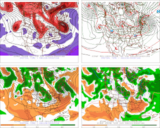
Tonights 00z ECM has come in with the 850 levels slightly warmer in SE PA...but otherwise to the North and West of 95 things are looking like they are below freezing at all levels. The surface temperatures are not available on the ECM but I have found that using the solid black line in the lower right hand image which is the 850s ...translates well for the surface temps. As long as you are on the north and west side of that line you should be below freezing or right at freezing at the surface.
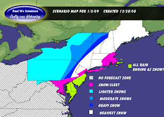
So my thoughts have not changed from earlier today and the scenario map that i made is still the same scenario that I would be looking at to happen and to occur!

Sunday, December 28, 2008

12 Z & 18 Z Model Update for January 3rd


For those of you who were waiting on this to be updated...I sincerely apologize for the lateness of it. However, my Father is in the hospital so that took my earlier time up today.
For some reason the 00z and the 12 Z of the GFS are having a problem with handling the pattern of the Greenland Block and the strong negative NAO with the rising PNA. However, when it comes to the 18 Z runs..and now this is two days in a row..the model takes a huge step towards the ECM. You can see at 126 hours that the primary hands off to a secondary around the southern Jersey coast and then it takes it NE up the coast line.
For starters, its a little too close to the coast..however it is slightly offshore. Secondly, i believe the hand off is still a little too far north. The ECM has been consistent on this secondary developing either over VA or just offshore of VA and I think that is the most likely scenario.
The ECM has been the most consistent with this storm and is colder and also more south and east. The ECM is also posted up above along with the 18 Z GFS for 126 hours.
So should we expect the 00z tonight to continue with and along the trend of trending to the ECM like the 18 Z was? I am not so sure about that. I think the 00Z might trend back to a more western solution. The GFS physics are simply not as good as the ECM at handling the pattern.
However...I am confident enough at this point that I feel i can issue a scenario map with using the ECM for the track of the storm and the GFS for the QPF. So this map is a blend of the GFS/ECM.....As always these maps are subject to change but given the consistency on the ECM..confidence level is 8/10

00z Model Suite Analysis for Jan 3rd 12/28/08


Worlds apart....
This is the best way to describe tonights 00z suite of model solutions. Its the ECM versus the GFS.
Lets look at the GFS first. As you can see at 144 hours the GFS holds on to the primary to long and tries to drive it directly into the confluence over the Great Lakes and the Northeast.
Tonights 00z GFS had many positives to it. First it had a stronger negative NAO. Second it had a stronger Greenland block. However..it took the 50/50 low and moved it to far north and the result was more of a SE ridge. Any forecaster worth his weight, knows that you are not going to have a SE ridge with a strong -NAO and a Strong Greenland block.
Moving on to the 00z ECM..This model has been consistent with its solution and has not been jumping around from run to run and is pretty much comparable to the 18 Z GFS. Imagine that the 18 Z GFS making more synoptic sense then the 00z run. Suffice to say that the 18 Z had a much better handle on the pattern then the 00z GFS.
QPF on the ECM is not as impressive as one would think it would be in this scenario. Again..I have to ask everyone to keep in mind that the teleconnectors are favoring more amplification and more amplification would also in my opinion, result in more QPF . I believe that will come in due time.
So thats a run down of tonights model suite. As soon as the teleconnections update for the evening I will follow this post with them.

Essentially I am expecting the secondary to develop over or just off the coast of VA. And then that secondary will ride NE from there.
Essentially i also believe that the thermo profile that you see on tonights ECM will be pretty close to the actual outcome. Still 5-6 days out but my confidence grows with each run of the ECM remaining consistent.

It actually reminds me of 1996 in the sense that the ECM was the most consistent on showing that particular storm which resulted in a blizzard. From a week out it never wavered. I am not implying that this will be a blizzard by any means..but i believe this could be a major snowstorm for those North and West of I-95 and odds just improved in my opinion for I-95 itself.

Saturday, December 27, 2008

18Z GFS..The Trend Starter!

18 Z GFS is the first model to come to the realization of everything that I stated in my prior post. Redevelopment starts over N VA at 150 hours! Continue to look for this to shift somewhat more south and east. Tonights 00z runs will be big! For the interior N & W of 95 this is a all frozen event on this model!

12 Z Model Suite Analysis for January 3rd


Good afternoon. Its time to analyze the 12 Z GFS and 12 Z ECM.. I am going to use the ensemble mean for the GFS and the precipitation maps for the ECM.
Looking at the 12 Z GFS operational run you notice it has one major problem. Its trying to run the primary low into the great lakes despite the blocking and despite the confluence from high pressure over the Lakes and the Northeast. However...as it continues to show from last night..if you look at hour 156 you will see an "X" off the south carolina coast. The GFS makes the error of putting too much emphasis on the primary when it should be transferring over to that "X" off the Carolina coast and developing the secondary. It finally develops this secondary but not until hours 168..
Looking at the ensemble means it appears that this is going to drop down from the plains as a clipper and then move on a East Northeast basis and go off the coast around Southern NJ or the Delmarva and then move northeast from there.
Looking at the ECM at 144 hours you can see that there is one area of moisture in the GOM. You can also see this looking at the 12 hr precipitation map ending at hour 156. . At 168 hours the low is sitting around Southern LI (approximately)..The mistake the ECM is making is the same mistake that the GFS is making in having the primary to far north.
The keys to this system are actually quite simple. The first primary piece of the puzzle is the teleconnections. The NAO is forecasted to be quite negative (posted last night) the PNA is rising and is expected to be slightly positive (posted last night)..This is key #1.
Key #2..is where does the secondary develop? Again the answer to this is relatively simple provided the teleconnections are correct. So what to look for in future model runs?
Look for the S/W dropping from the plains to dig further to the south and to the east. Meanwhile look for the S/W in the GOM to lift NE and converge and develop into a low pressure system somewhere between VA and the Delmarva and then to track to the Northeast from there.
The teleconnections in place argue for more amplification and the trough digging deeper. Be back for the 00z model suite!

Latest Teleconnections Updated..


The teleconnections are posted above....

Generally speaking the NAO is forecasted around the time period to be pretty negative and then approaching off the charts negative.

The PNA is expected to be neutral to slightly positive...

The EPO is expected to be positive and significantly positive by the end of the period...However..at this time frame in question it looks to be more neutral...

Generally a Positive EPO would mean warmer air across the east coast. However..as one sees the NAO is off the charts negative and this is one cold signal. When you couple the NAO with a rising PNA and rising into the slightly positive category then you are arguing for more amplification despite the positive EPO.....
So not much, if anything has changed on the teleconnections. If anything a stronger NAO forecasted. So these connections are going to tell the tale of what happens with this next storm on or around the 3-4th of January....

December 27th Weather Discussion

Remember the roller coaster ride that I was referencing in earlier posts in regards to the weather and the temperatures? This trend is going to continue for the next couple days as we experience some warm southerly flow for this time of the year. But just as before we got to the top and we took the plunge...That plunge is coming once again.
For today we will be looking at mainly cloudy skies with scattered showers over the area. However from Central NY on north the precipitation will be more concentrated in the form of rain in Central NY to Snow changing to ice over Northern Maine and then even to plain rain as the southerly flow advances northwards.
Temperatures will generally be in the upper 40s to lower and mid 50s across all of PA and into NJ...To the south of PA temps will be in the upper 50s to mid 60s. To the north across northern Maine temps will start off in the lower 30s but actually be on the rise. Southern New England upper 40s to lower 50s as well.
Thats your update on the general weather and stay tuned to find out when this plunge will occur and also how much of a plunge and does the teleconnections and guidance have a snowstorm in the makings for the mid atlantic into the Northeast?

00z Model Suite Analysis for January 3rd...


Wow...Can you say that there is no harmony between the models tonight? At hour 168..the 00z ECM still has the southern shortwave in the GOM...Meanwhile at 168 hours the GFS has the southern S/W essentially phased with the clipper dropping down out of Canada and is causing this low pressure to cut up towards the Great Lakes.
However...the GFS while cutting it towards the lakes basically realizes that it runs into strong blocking from a 1037-1039 high pressure area. So then it realizes that it can not go further north..cuts itself off and then jumps to the east coast via route of PA...at 192 hours.
Meanwhile the ECM has the Southern S/W in the GOM at 168 hours and then at 192 hours it is in eastern Maine.
So you maybe asking yourself which model makes more synoptic sense with the teleconnectors that are in place. Technically, I think they both have some aspects of truth to them. I believe that you are seeing a slower trend on the 00z suite tonight compared to 12 Z runs which indicates that the blocking is starting to be realized. With the NAO tanking and the PNA on the rise..the models are starting to dig the Northern S/W further south on the 00z runs.. Now where I believe the GFS is going in the wrong direction is it is focusing too much energy on the primary clipper instead of the southern S/W. When looking at hour 174 you can see the GFS actually has another S/W off the delmarva coast..This is where the secondary should pop on this run....but with the models initializing in a positive NAO because thats where we are now..They are having a hard time adjusting to the development of the NAO....
So as i stressed earlier this afternoon...keep an eye on the teleconnections and as soon as they update I will post them here. Thats all for tonight on this 00z Suite..

Friday, December 26, 2008

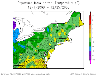
December Daily Departures at KABE & Overall Image for NE!


December 1st Positive 2
December 2nd Negative 4
December 3rd Negative 6
December 4th Positive 3
December 5th Negative 9 (Edited to meet the NWS)
December 6th Negative 11 (Edited too meet NWS)
December 7th Negative 10
December 8th Negative 14
December 9th Seasonal (No Departure edited to meet NWS final #)
December 10th Positive 15
December 11th Positive 3 (edited to meet NWS)
December 12th Positive 2 (edited to meet NWS)
December 13th Negative 6 (edited to meet NWS)
December 14th Negative 1
December 15th Positive 18 (RECORD HIGH 61 BROKE 1918 record of 60)
December 16th Positive 8 (High of 51 came at midnight yesterday)
December 17th Positive 3
December 18th Positive 3
December 19th Negative 2
December 20th Negative 6
December 21st Negative 3
December 22nd Negative 15
December 23rd Negative 11
December 24th Positive 9
December 25th Positive 7
December 26th Seasonal -No Departure


Overall for the month Negative 1.3

Teleconnectors and Ensembles..why they are important.


Teleconnectors are important as they over all are what control our weather. It is there signals that determine where cold air will be. Where amplification will be. In winter time, where snowstorms will be. Where storms should be and should track.
Ensemble means are just as important because they take all the individual ensemble members and blend them into one solution. Sometimes the Operational run will trend towards the ensemble means and yet others the Ensemble means will trend towards the operational run. When the ensemble mean generally stays consistent the chances of the operational run trending towards that consensus solution become better.

So with the above said lets look at the teleconnectors in reference to the January 3rd time frame...
As you can see the NAO is expected to become quite negative on the charts above. The PNA starts negative..but what is important to realize is that it is rising and becomes positive. These two teleconnectors argue for a solution that would be more amplified then what is currently being shown on todays model runs.
Its too early to get into specifics on this storm system. The thing I encourage everyone to keep an eye on is these teleconnectors.The ensemble mean of the GFS is actually more in line with these connections. In the sense that it is showing an off the coast solution-Miller B...
The 12 Z ECM Ensemble mean was also further south with the secondary off the coast of Southern Jersey.

With the transition into a different pattern..You are going to notice that models are going to flip flop from one scenario to another. However..the overall method to keep yourself from going crazy with each run is to watch those teleconnections. With those teleconnections you can tell whether a model is close to a correct solution or is still not in touch with the upper air patterns.

Tuesday, December 23, 2008

December 23, 24th Pre Christmas Storm


A rather strong cold arctic air mass covers the area the past 48 + hours and is starting to retreat from the area. A storm system approaching from the SW will bring WAA with an advancing warm front. This WAA will rise over top of the very cold air at the surface...Temperatures are generally in the low to mid 20s and colder the further north that you go. Ground is quite frozen from the preceding arctic air mass. So the WAA will cause precipitation to break out and this is what my current thoughts are right now based on the GGEM and the ECM...

Friday, December 19, 2008

December 20-22nd Wave # 3


Low pressure approaching from the southeast...While at the same time a low pressure drops from Canada into the Great Lakes.


At this time the low pressure appears it is going to be too close to the coast to once again offer those along I-95 any substantial snowfall. However..to the north and the west Snow and ice will be the norm..rather then the exception.
If the coastal low can trend stronger and move to the south and east, and the primary trend weaker then we could be looking at a different scenario. However for now here is my preliminary map and what I am thinking.

Thursday, December 18, 2008

December 19-20 Wave #2 Final Map


An upper level low over Southern California is going to Acellerate ENE over the next 24 hours and end up off the coast of NJ to a position south of Long Island. Meanwhile High pressure will be over SouthEastern Canada funneling in lower level cold air once again at the surface.
This storm has the potential to be the most widespread accumulating snowfall of the pre winter season thus far. Winter Storm watches have been issued for alot of locations already. The heaviest snow should fall to the north of the S/W track...

Wednesday, December 17, 2008

December 17th Weather Discussion

December 17th Weather Discussion
The Climb, the plunge and now level track


Well as I talked about yesterday we definitely took that plunge from a record breaking high temperature at KABE of 61 (broke the record of 60 from 1918) to a round of wintry weather of Snow sleet and freezing rain.

Across the region today we are going to continue to see that ZR across most of PA, except the SE corner, and into SE NY and Southern New england(except right along the coast) and then into NW NJ....Southern Jersey all rain and then further north into New England will be the snow.All this precipitation will begin to come to an end sometime after 7-10 AM except later further north that you go.

Temperatures today will start in the upper 20s across eastern PA and NW NJ. For high temperatures they will basically be seasonal levels with the upper 30s to around 40 across eastern PA and into NW NJ..upper 30s to low 40s southern New England..Interior Northeast temperatures will be in the lower 30s. Interior regions of NW PA mid 30s all other areas upper 30s to lower 40s with the exception of Philadelphia where mid 40s will be possible. To the south of the PA/MD border low to mid 50s.....

Stay tuned to find out whats coming at you next weather wise! Have a good day!

Preview for Wave #3 (Dec 21-22nd)


This map is based on a blend of the 12/17/08 00z GFS and 00z ECMWF...Again this is just a scenario map and not a forecast....

December 19,20 Wave #2 Scenario


The above map is based completely on the 00z NAM and what it is showing as of tonight the 17th. Basically, over the next 24 hours i expect this to continue to trend slightly south and also colder..however this is what I see at this point and time...

Tuesday, December 16, 2008

December 16th Weather Discussion Including Over running Event..


As i have been discussing for quite some time the Roller Coaster ride continues with todays forecast. At the present time we have an arctic cold front heading thru the area. This arctic cold front will make it to the east coast before stalling. This front will drop temperatures in less then 24 hours over 25-30+ degrees once it goes thru your area. This will allow cold air to filter into the region ahead of an advancing wave of low pressure. This weak open wave will ride ENE along this boundary delivering snow and ice and rain depending on what side of the boundary you lie on. To get a general ideal of what you can expect my map will be at the top of this post....
Your high temperature today occurred at midnight ..from there its just that decline downwards...Depending on where you are located later today and overnight...be careful when driving due to the snow and the sleet....

Just a note on the map for the NYC area you should be in the pink area and for Cape cod area ..basically expecting 1-3 inches of snow but that could end as rain and you are dependant on the cold front making its way that far east and the cold air arriving ahead of the precipitation...Otherwise all other areas are pretty much explainable....