Relaxation in the Pattern-Its Only Temporary!
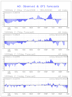
As everyone knows a pattern has to relax at some point and time and that is exactly what is going to happen to some extent. Looking at the teleconnections we come across the following when looking at the ensemble connections.
The Arctic Oscillation is now neutral. When the Arctic Oscillation is essentially neutral the cold air relaxes and that is exactly what is going to be occurring.
The EPO is going to be mainly neutral to positive. When the EPO is neutral to positive it generally means warm Pacific air will infiltrate most of the US, and keep things warm - especially across the northern 1/2 of the country.
However...the PNA is positive which generally means downstream effects of a +PNA are typically for a West coast ridge/East coast trough pattern.
And then the NAO is neutral to negative which generally means downstream effect of this feature is for cold conditions to occur along the East Coast.
Lets go back to the Arctic Oscillation. As i stated at the beginning the AO is neutral which means that the cold air is relaxing. When it relaxes what is actually occurring is the cold air shifts back up into canada and starts to get bottled up.
So when it comes to the teleconnections in place what we are looking at is one signal which would indicate warm pacific air penetrating the US but we have three other signals that indicate a colder then normal scenario.
Now, lets once again go back to the Arctic Oscillation. When cold air is locked up over Canada it starts to build up. And kind of compare it to a bottle of Pepsi. The lid is on when you purchase the soda but what happens if you shake that bottle of pepsi and then remove the lid without waiting? That soda would "explode over and spill out" and head southwards down the bottle and on to the floor or where ever you happen to be at that time. The AO works the exact same way and we see that 7 days from now the AO is expected to tank once again.
So we have one teleconnection that would favor milder air being outweighed by three teleconnections that would signal a below normal regime and then a strong signal of the AO tanking.
So, my take on what is going to happen is that a ridge is going to try and build into the region the early part of this week. However..because of the teleconnections that are in place this is going to help to establish a mean trough in the east central part of the USA. So we may be looking at a period of a couple days at maximum that get to seasonal to perhaps slightly above normal temperatures before once again sliding back down to below normal.
The feature that will help to establish this mean east central US trough will be a a S/W that comes out of Southern California heads off to the east before moving NE into the Great Lakes region which will then send a cold front across the eastern half of the country which then helps to establish the trough into the east. This will provide a very wet pattern to the eastern half of the country in addition to turning the temperatures back to below normal. This wet pattern is also another reason why the temperatures will only get to seasonal levels.
There is a question as to how much the remnants of Hurricane Rick get involved with this as well. At the time that the remnants of Rick would be moving across TX ..there is a trough that reaches its southern extent into that area. So, if that trough can manage to pick up the remnants of Rick..then this would enhance the rainfall associated with the cold front progressing to the east.
So overall, look for a few days of seasonal to slightly above temperature to be followed by below normal temperatures once again to carry out the rest of this month. Also look for an increasingly wet scenario towards the end of the week .

No comments:
Post a Comment