Wednesday, September 30, 2009
Midwest Pattern Update Oct 1-6 2009
Midwest Pattern Discussion for Oct 1-6, 2009
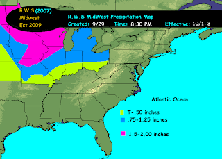
An upper level low will be approaching the region. This upper level low is going to be responsible for two things. First, will be rainfall. This rainfall will start to move into Iowa and Missouri by thursday. This rainfall will work and spread its way to the north and to the east. At this point and time it looks like anywhere from just under an inch in ohio to potentially as much as 2.5 inches of rain over Iowa could fall. It looks like we will keep rainfall in the forecast thru about sunday ..however..western areas should start to dry out before that.
By monday this upper level low will be up into Southeast Canada but another S/W and its associated trough will be making its way towards the region by early to middle part of the week. In the tuesday-wednesday time frame and this too will create more rain across the region.
The second thing that this ULL is going to be responsible for is the temperatures. Temperatures generally looks to be chilly with highs in the 40s and 50s thru this time frame.
Sunday, September 27, 2009
Southeast Weather Discussion For Oct 1-6 2009
A cold front has swept thru the southeast. This cold front has also pushed any rainfall to the east as well and with it will come clearing conditions however , cooler conditions. After alot of heavy rainfall, it appears the southeast will be going into a pleasant weather pattern consisting of sunny skies with temperatures generally from the 60s to 70s.
Next cold front (stronger) to push thru on monday. This front should be relatively starved for moisture. can't rule out an isolated shower but for the most part the pleasant weather will continue. Temperatures at night could get down into the 40s across parts of the southeast.
Next chance for any rain would not be until the weekend when another ULL drops down from the midwest with an attending frontal system. ATTM , there is a chance that a low pressure develops along this front , however will worry about finer details on that potential as we get closer to the time frame. Meanwhile enjoy the pleasant weather stretch as it is well deserved.
Friday, September 25, 2009
Wednesday, September 23, 2009
September 23rd Daily Weather Discussion
Greatest rainfall in a year ever recorded?
Answer: 1,041 inches (Assam, India; August 1880-1881)
Imagine that!
Todays trivia question:
Lowest Northern Hemisphere Temperature ever recorded?
September 23rd Daily Weather Discussion
Fall has fallen but summer was in the air!
Today is going to be more like a summer day then a autumn day. Funny how we changed roles a little bit here. Majority of the region is going to be once again under partly to mostly cloudy skies with scattered showers. Best chance of this will be across the northern tier of NY and north. Otherwise more to the south just scattered and more isolated in nature.
Temperatures across the region....upper 60s to upper 70s in Maine..else where upper 70s to perhaps some lower 80s.
Stay tuned for the answer later today...
Tuesday, September 22, 2009
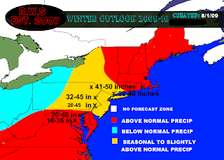
Select Cities Snowfall Potential Winter 09-10
Select Cities Snowfall ..
Scranton Pa -normal is around 41 inches ..Forecasted amount 41 to 50 inches
Allentown Pa -normal is 32 inches..Forecasted amount is 32-45 inches
Philadelphia Pa -Normal Snowfall is : 20.5 inches...Forecasted amount 20-45 inches
New York NY -normal is 22-28 depending where in NYC.. Forecasted amount is 22-40 inches
Baltimore Md - normal is around 20 inches..forecasted amount is 20-40 inches..
Washington, Dc Normal is around 16-22..forecasted amount is 16-36 inches
Monday, September 21, 2009
September 22nd 2009 Daily Weather Discussion...
Greatest snowfall in a single storm?
Answer: 189 inches (Mt. Shasta, California; February 13-19, 1959)
September 22nd 2009 Daily Weather Discussion...
High temperature at KABE on the 21st was 75 degrees...
The first day of fall has arrived...
The first day of fall has arrived and generally speaking the weather is going to be a pretty typical fall day across the region. Maybe even slightly above normal with the daytime highs depending on where you reside.
Majority of the region will be under partly cloudy to cloudy skies at times..though i think that areas will also see sunshine pretty much of the day, especially the further east that you go. With a cold front making its advance towards the region there are showers out and about which on the eastern side of the spectrum will be more of the scattered variety. Best chances of shower activity will be on the western side of the region...
Daytime high temperatures look to be mid 60s to upper 70s...until you head south of the border where temperatures will be in the upper 70s to lower 80s.
Todays trivia question..
Greatest rainfall in a year ever recorded?
Find out tomorrow
Pattern Update for Sept 20-27 2009
I have come to the conclusion that instead of covering the weather pattern for two weeks at a time that I would cover the weather pattern 1 week at a time much like I am doing for the southeast.
The next 24-48 hours are going to be controlled by an area of high pressure off the east coast which will be responsible for building a ridge over the area. This high pressure & subsequent ridging will be responsible for a southerly flow and a temporary moderation in temperatures where we could be looking at potentially above seasonal levels. However..do not get use to it. A cold front will approach the area from the west on thursday into friday.
Meanwhile over the southeast they too will be under the influence of the upper level ridge as the closed ULL over the west retrogrades into the rockies from the plains.
By about 96 hours out or friday, with the cold front advancing, a trough over southeast Canada will amplify into the northeast and this will send temperatures once again back to seasonal to slightly below seasonal levels.
By about 120 hours out the closed ULL over the west is going to start to make inroads into the east.
By about 144 hours out this trough will essentially be over the Great Lakes and the east coast.
As far as precipitation is concerned. Generally any rainfall over the next couple days in association with the cold front approaching will be generally light between a T and approximately .50 on the eastern side of the region to approximately an inch on the western side of the region. Ohio though can see more rainfall with over an inch possible.
There after with the trough moving into place...an area of low pressure could develop over the southeast and move up the east coast bringing a soaking rain to parts of the region. As the time comes closer to this will consider issuing a map for the rainfall that may fall across the area.
Temperatures across the region as stated will be seasonal to slightly above seasonal over the next couple days as the ridge is in control. With the passage of the cold front thursday into friday temperatures will drop back down to seasonal to slightly below seasonal depending on where you reside. With the trough moving into place over the weekend from about sunday on temperatures are expected to be below normal across vast majority of the region!
Southeast Pattern Update for the week of September 20-27,2009
The persistent low that has been responsible for the excessive rainfall in the Southeast is beginning to weaken and move off to the north. Unfortunately, however, there is more rainfall to contend with with the approaching of cold fronts to the region. These cold fronts are still enhancing rainfall across the region where they have already recieved on the order of 20 inches in some locales.
A upper level ridge will move into the region for tuesday into wednesday. As an ULL retrogrades to the Rocky Mountains. By mid-late week the upper level ridge will then retrograde to the MS valley as a trough amplifies over the northeast. From there we pretty much will be into a more progressive type flow with the ridge axis reaching the appalachians.
One cold front will reach the region on thursday..There is a question as to how far south this particular cold front will reach. If it reaches far enough south it could cause an area of enhanced precipitation once again across portions of the southeast. Another cold front reaches the area on Friday late. This cold front also has the potential to enhance rainfall over the southeast.
So the question becomes does the southeast even get a break from the rainfall in between the persistent low moving out and the approaching cold fronts? I think its possible that wednesday would be the day where things tend to dry out but that drying out process will not be long...
The upper level low that has been responsible for all the rainfall in the southeast will still be over the MS valley next Sunday. So the forecast over the next week generally looks to be quite wet with only a brief break in between weather systems.
I believe the region will overall have to wait until the 28th before we can actually get some real drying to occur...That is also the time period that I expect cooler temperatures to move into the region. In the sunday to monday time frame. Until then temperatures will be seasonal to above seasonal across majority of the southeast.
Its really impossible to pinpoint rainfall totals that could occur within this time frame due to the uncertainty of the extent of the first cold front on thursday and the moist atmosphere currently in place due to the ULL that has been producing the rain. Its possible that over parts of the SE an additional 1-5 inches of rainfall could occur over the next week.
Also watching the remains of what use to be hurricane fred moving off to the west towards the southeast coast and what type of effect he will have across the southeast and in what shape and form. At this time i feel that anything from Fred should mainly impact right along the coast of the southeast but never the less will keep an eye on that as well...
Sunday, September 20, 2009
September 21st Weather Discussion
A little warmer then yesterday!
Yesterdays Weather Trivia Question:
What is the longest tornado path ever recorded?
Answer? 293 miles on the ground, 1917, traveled from Missouri to Indiana.
Today is going to once again be a relatively sunny day across vast majority of the region. However, areas to the west may experience some afternoon showers..Otherwise sunny skies will be across the area with temperatures slightly warmer then yesterday! Some locations may actually step above seasonal levels while others get within or close to seasonal levels.
Temperatures will generally be in the mid-upper 70s across the region! So if you happen to be in an area that does not end up seeing clouds and showers, you might want to take advantage of this day in the outdoors.
The high temperature for the 20th of September at KABE was 72 degrees..
Todays trivia question....
Greatest snowfall in a single storm? Tune back in tomorrow evening to find out this answer!
Winter Outlook 2009-2010 By Jim

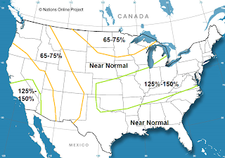
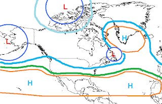
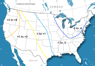
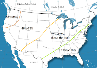
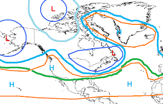

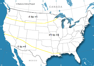

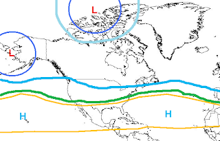
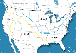
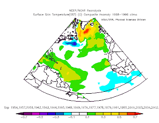

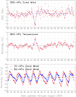


Refer to all images above when reading discussion below :
2009-2010 US Winter Outlook
Alright, before I get into it a few things. First off, this is my first winter outlook ever, so chances are the results may not be what I would like. However, I think I have read up enough on sites like MetEd and have read what mets have posted on weather boards such as eastern for a couple of years now so I think I have at least the basic understanding, and do have to start somewhere.
The outlook is broken down into two main sections. The first one is just trying to get down the main pattern that will set up, especially over the Pacific and trying to pinpoint where any high latitude blocking will be if it happens. The second section is going to try to time things and break them down at least month by month if not a little smaller range if I feel that I can do that.
Pacific Pattern:
The first important thing I’m going to look at is the state of the ENSO, and what it looks like it will try to do from here. Right now we are in a basin wide weak El Nino. There has been some cooling over the last couple weeks, especially over regions 1+2, which are the most variable. This may be in response to the SOI going very positive and the AAM a little bit above normal which promotes somewhat stronger trades. And on top of that, the southern hemisphere is actually looking quite Nina-esq with cooler waters running up the S. America coast with a large polar vortex causing a strong surface high to the west of S. America continuing to cool the waters and funnel them up the coast towards the equator. Also, sub surface temperature anomalies have gone below normal over the eastern Nino regions. So, this leads me to believe that we will not get an east based event.
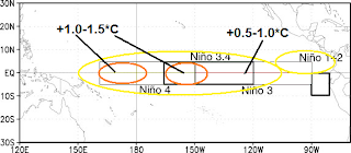
Speaking of sub-surface temps, east of 120W the subsurface temps have cooled, however west of there the waters are warm all the way down. So, the water being upwelled west of 120W will not be all that cold. But, with trades remaining fairly strong for an El Nino event some of the cooler water over the eastern equatorial Pacific near the surface may move west some, so I think areas east of 120W will cool to between 0 to +.5 degrees C, areas between 120W and 160W will cool to +.5 to +1.0, and areas west of 160 N will remain close to where they are now, +.8 to +1.2 as we head into winter. So, the Nino is definitely kind of basin wide right now, but assuming trades can remain somewhat strong and continue to upwell and push some of the colder waters west I think the Nino will become more west based by winter. So, not to copy off of Chuck here but this is what I think the anomalies will look like come DJF within 10 degrees of either side of the equator (outside of there I didn’t look at).
Now, over the northern Pacific…while this may not be quite as important as the ENSO phase it is somewhat important with relation to how strong the PNA is, and where the vortex will set up over the far northern Pac. Over the summer the PDO spiked a bit and did become more neutral, but over the last couple of weeks the waters over the NE Pacific and over the Gulf of Alaska have really cooled, and there is now a large area of negative anomalies over the NE Pacific, with the NW Pacific pretty much a wash with warm anomalies to the north and cooler anomalies to the south.
Now, logic says the Hadley cell over the Pacific will be strongest west of 150W, which is where the best tropical forcing due to warmer waters along the equator is expected to be. This will create a stronger gradient on the northern edge of the cell over the western Pac (west of 150W). This will create more storms in general there and a stronger jet stream over the western Pac. This would probably put a strong upper level low to the northwest of 35N/150W, which happens to be where most of the ENSO/PDO related anomalies I used put it. Farther east over the eastern Pacific and closer to the west coast the Hadley cell shouldn’t be as strong, so the jet will be a bit weaker there. This should allow the upper low (which will probably be in the vicinity of the Aleutians a lot of the times so we’ll just call it an Aleutian low) to at least try to pump up heights some close to the west coast and possibly over western Canada. While the overall configuration/strength of the ENSO related anomalies will be favorable for this setup that would lead to a +PNA/-EPO, the cold waters over the NE Pacific/GOA has me concerned that strong ridging over the western portions of the continent may have at least some trouble forming.
With the cold waters off the NW coast and off of western CA/AK any S/Ws over that region may have a tendency to try to move more southeastward over that area possibly knocking down the ridging on the west coast from time to time. With the Nino not being particularly strong, I’m not sure the Nino induced Aleutian low/-EPO will be overly strong and overcome this, so while I definitely don’t see a large trough on the west coast with a strong flow screaming off the Pacific into the west coast, I don’t think we’ll see S/Ws riding well north into Canada north of a -EPO/+PNA combo and then dive south into the central/eastern US, the pattern may be less amplified most of the time on the west coast.
Now, like I said I did use some ENSO/PDO related analogs. I didn’t focus my whole forecast around them, but mainly because this is my first shot at a long range outlook I did want to plug in some analogs to see if I have at least some sort of a general right idea about the Pacific pattern…for analogs I used the September SST anomalies over the Pacific. Was looking for a weak Nino, preferably neutral or west based, with some sort of a cool pool over the NE Pacific in September. Based on these criteria these were the analogs I came up with:
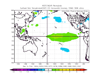
1963-64 (w), 1965-66, 1969-70 (w), 1977-78 (w), 1987-88, 1991-92. Analogs with a “(w)” next to them indicates I think the analog is somewhat useful but a bit weak based on what I was looking for, and gets a weight of 1, analogs with nothing next to them I thought were somewhat better and got a weight of 2, the bold and underlined analog was the analog I though fit best based on Pacific SSTs in September, and got a weight of 3. With that said, here is what the DJF SST anomalies over the Pacific looked like with those analogs:
So, my ENSO forecast was somewhat close to what the analogs show which does give me a little more confidence. The northern Pacific is also somewhat close to what I would envision, so the analogs are giving me the idea that I might be somewhat close.
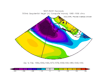
Here is what the Pacific 500MB height anomalies look like with these analogs:(see above)
Alright, so those analogs do show a nice Aleutian low, with as I suspected marginal at best +PNA/-EPO, which may even be weaker because the ENSO the analogs show is a bit stronger than I would expect it to get.
So, in summary for the Pacific I think that as we get into winter a typical west-based El Nino Aleutian low will develop. The Hadley cell will be stronger due to the El Nino increasing tropical forcing along the equator causing a stronger sub tropical jet on the northern side of that. The northeastern Pacific is holding us back some though…I believe with cooler waters over that region S/Ws may have some kind of tendency to drop more SE towards British Columbia or the NW US limiting how amplified any +PNA could get. Overall this would result in a less amplified pattern over the western US, and this may cause S/Ws to phase with the subtropical jet a bit west for the east coast’s liking, but I don’t think the Pacific will really hold us back, hopefully at least. I don‘t think we‘ll get a raging +EPO that floods the continent with warm air. The Pacific is kind of neutral, and the quality of this winter may depend more on high latitude blocking to amplify the pattern, which I’ll get to next.
Atlantic Side/High Latitude Blocking:
I know other mets have done this before, but I’m trying to keep this outlook my own work as much as possible. So, I’m going to plug in analogs that ended up with a -NAO to get an idea of what the September and then DJF SSTs looked like to see if that gives us any clue to what the SSTs could give us this year.
-NAO Sea Surface Temperature Anomalies:
September SSTs:(see above)
A couple of things that stand out…
1. Warmer SSTs up over the NAO region which really shouldn’t be much of a surprise.
2. Cooler SSTs down close to the equator.
Resulting DJF SSTs:(see above)
Not very surprising again, warmer temps over and just south of the NAO region, and near normal to slightly below normal water temps closer to the equator.
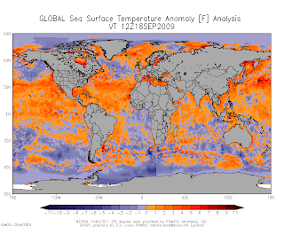
Now, as we look at the current sea surface temperature anomalies on the Atlantic side:(see above)
Right now, the water temperatures over a lot of the northern Atlantic are below normal, but it is important to note that water temperatures surrounding Greenland/Iceland are above normal and those positive anomalies are trying to expand some. So, the current pattern up there may not favor a -NAO right now but it might be getting there. Also, the equatorial temperatures in the Atlantic are slightly below normal. This favors weaker tropical forcing in that area which favors a weaker Hadley cell over the Atlantic. I’m just going out on a limb here, but I would guess that if the cell is weaker, the pressure gradient on the north side of it will be weaker, so the polar jet over the Atlantic come winter will not be as strong. This may favor somewhat warmer heights being pumped northward if the jet is weaker and has an easier time amplifying. So, the sea surface temperatures on the Atlantic side may be somewhat favorable for a -NAO, especially along the equator, along the cooler temperatures over a lot of the northern Atlantic may be somewhat of a limiting factor, but things like a weaker Hadley and stratospheric warming could overcome that fairly easily.
QBO/Possible Stratospheric warming:(see image above)
Right now the QBO is going into the easterly phase, as there are negative anomalies showing up at 30MB, and the 50MB winds are starting to level off and weaken as well. Positive zonal wind anomalies are indicative of stronger westerly winds in the upper atmosphere and negative anomalies indicate easterly winds in the upper stratosphere. As you can see, at the 30MB the winds have become easterly, and at 50MB the positive anomalies are becoming weaker and soon will become negative, or easterly winds, thus we are heading into the eastern phase of the QBO as the easterlies propagate downward.
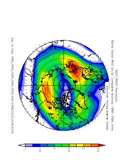
So, what does this all have to do with winter in the northern hemisphere, more specifically the AO/NAO. Well, if the QBO is negative or in it’s “eastern” phase it promotes a weaker or displaced polar vortex. A polar vortex often makes it harder to get sudden stratospheric warming events that could translate to a -AO/NAO. But, a weaker or displaced polar vortex makes it easier to see stratospheric warming events which can often translate to strong high latitude blocks. Just to show what an easterly QBO can do, notice these 50mb wind anomalies over the arctic regions:
Note that the winds are a few m/s weaker than normal. They show up as easterly anomalies, because the winds aren’t as strong from the west as they normally are with an easterly QBO. Now, the polar vortex is still there, but as shown above it is just weaker which makes it easier to see stratospheric warming events:
So again, the PV is usually still there.
But, what this all means is that if we can get something to induce stratospheric warming such as some solar “activity” it shouldn’t have a hard time getting that to happen with a QBO that is going more easterly. Right now the easterlies are still somewhere between 30-50MB, so it will take a little while for them to propagate down to the point where they have the most impact on stratospheric temperatures. It may not get very favorable until January or February, but by the end of winter the QBO will be favorable for stratospheric warming. With a weakened Hadley cell any sudden stratospheric warming event could translate down to a high latitude block or -NAO/AO. If we can get cycle 24 to actually and become somewhat active sometime soon we could have some solar induced sudden stratospheric warming events especially during the second half of winter. So, I think the odds of getting a good -NAO/AO block for at least some period of winter, especially during the second half are fairly good with cooler waters over the equatorial Atlantic and half decent prospects for a sudden stratospheric warming event.
Preliminary NAO forecast:
December: Neutral to positive
January: Neutral-positive becoming more variable with a potential -NAO especially as the month goes on.
February: Variable but the potential for a -NAO block, possibly a strong one seem high. Should average out to be a -NAO month if I’m correct.
This may not work out but here is my NAO guess:
So, what this all boils down to…(see above)
Forecasts by month:
December temp anomalies: (see above)
December precip anomalies:(see above)
December overall 500MB pattern:(see above)
So, in summary…I believe the pattern in December will be somewhat flat. There could be some sort of an attempt at a +PNA but with the NAO probably not being very helpful and a somewhat flat pattern off the Pacific there won’t be any great sources of cold air, so a lot of the CONUS will probably be above normal temp wise for December. With a strong STJ and a possible storm track from the southern Planes through the OV into the upper M.A. (could see a Panhandle hook or two especially first half of the month, if we can find a way to amplify the pattern a little) there will be some areas that see above normal precip, especially along the aforementioned storm track. During the second half of the month could see some sort of MJO induced heavy rains along the west coast and possible warmer weather over the eastern half of the nation, possibly the SE ridge briefly flexing its muscles at this point.
January (see images above)
I really think this month will be atypical for an El Nino, mainly due to the PDO and cold waters over the NE Pac/Gulf of Alaska. I do think we’ll see some kind of an Aleutian low with maybe an attempt at some sort of a +PNA, but I think the colder waters will cause S/Ws to come in and knock down any ridging over the west quite a bit. This will cause the cold to end up farther west than your normal El Nino with a +PNA/EPO configuration would give you. Now, later in the month I think the NAO will attempt to go negative, and we could see a good 50/50 and -NAO combo for some point at the end of the month. This could shift the cold and storm track east closer to the Mid Atlantic by the end of the month so I will not put any positive temp anomalies there, although the first half of January could well be cool/wet/stormy over the lower GLs/OV/New England and warmer and somewhat drier over the Mid Atlantic/southeast because the northern branch will be getting too far south too far west, and if we get an active southern branch with a neutral NAO like I think we’ll see the first half of January, any storms will phase rather far to the west and head up into the Apps or even lakes. So, quite frankly January, especially the first half could end up looking somewhat Nina-esq with the cold/snow back closer to the Midwest with the northeast ending up rather mild.
If we get a negative NAO to try and form during the second half of the month, the storms could stay a little to the south and the northern Mid Atlantic and the southern portions of New England could get in on some snow then. Slow start to the winter for sure for the Mid Atlantic, southeast, and even SNE if I’m correct here.
February (see images above)
Alright, this month could be a lot of fun. I think the key here is the Pacific. I have pretty decent confidence in the NAO and possibly AO taking a nose dive and staying negative for a lot of the month of February. The key is if the freakin Nino can flex it’s muscle and maybe cause some sort of a +PNA despite the colder waters over the G.O.A. I think that after a few months of the G.O.A being east of a decent Aleutian low, we may finally be able to build the heights enough to maintain half decent ridging over the west. If we can get this western ridging, the eastern 1/3 to ½ of the CONUS freezes. If we still can’t get decent western ridging for whatever reason, I think the cold is less severe than what I show above and probably a little farther west.
If we can get the +PNA to coincide with a -NAO this month, I think the storm track will be just off or possibly along the east coast. I think we may have trouble seeing a large +PNA ridge that forces storms to track far east, like along the 40/70 benchmark, but more like along the coast, which may keep the immediate coast from freezing this month. Now, if the +PNA is even weaker than I’m thinking or even doesn’t come to fruition, again this month is probably a lot less extreme and everything gets shifted to the west. Now, with a potential very negative NAO this month, possibly coinciding with a +PNA and enhanced STJ, if we do get a triple phaser, it would either be in February or early March, at least IMO. The pattern I show is probably amplified enough for one if we get a rather potent piece of energy to come diving in on the polar jet. Now, for this to happen we would first need to get my forecast 500MB pattern to verify, and then actually get a very strong S/W to come screaming down and then phase with the subtropical branch and pull the arctic branch in. So, the odds of this happening are still somewhat low but are definitely higher than most years. Triple phasers do only happen once every 10 or so years in the US, just for some background on how rare they are.
So, if I had to summarize this winter in like one sentence, I would say: Starts slow in the east, but ok in the lakes, but by winter’s end the west is warm, east is cold, and lots of storms will probably be seen.
I did bat around the idea of if I wanted to do this or not…but I will attempt a DJF overall snowfall anomaly map (% of normal, as are all of the precipitation anomaly maps):(image above)
Saturday, September 19, 2009
September 20th Weather Discussion
Trivia Answer: 286 miles per hour (Wichita Falls, Texas; April 2, 1958)
Imagine that coming to a location near you! No thank you!
September 20th Weather Discussion
Crisp in The Air..is Autumn here?
No, officially Autumn is not here but many places are or have been experiencing autumn weather with below seasonal temperatures. Daily high for sept 19th @ KABE was 72 degrees. Today looks to be more of the same fine weather that we have been experiencing. Fine, if you like sunny skies and cool temperatures. That is going to be the weather today..sunny and seasonable to sunny and cooler then normal. All depends on where you are..
Temperatures from the mid 60s to mid 70s across the region...south of PA mid 70s to around 80 degrees.
Todays Weather Trivia Question:
What is the longest tornado path ever recorded?
Tune in tomorrow to find out the answer!
Friday, September 18, 2009
September 19th Daily Weather Discussion
What was the greatest snowfall ever recorded in a single day?
Answer was : 75.8 inches (Silver Lake, Colorado; April 14-15, 1921)
Thats alot of snow there
September 19th Daily Weather Discussion
Pleasant Weather continues!
September 18th Daytime high at KABE 73 degrees
Todays weather is going to consist of mostly sunny skies across the region and with the sunshine out in full force it is going to feel quite pleasant . Temperatures will once again be seasonal to slightly below seasonal levels and more like an autumn day ahead of the scheduled start of autumn.
Mid 50s-upper 60s thru out the interior regions of the Northeast. Along the coast from SNE south and east upper 60s to middle 70s. South of PA temperatures will be in the mid 70s to lower 80s.
Todays Trivia question:
Fastest Tornado Winds ever recorded? Tune in tomorrow to find out the answer to this particular question.
September 18th Winter Pondering Thoughts
1. Been pretty much expecting a weak el nino to ride us thru the winter time...
A. This El Nino is actually a very unusual El Nino as it has no clear El nino trends.
This brings me to point #2..
2. El Nino years generally like negative SOI....
A. SOI while was negative is clearly on the rise and is now into positive territory...
14-Sep-2009 1015.35 1013.80 -4.57 0.03 1.04
15-Sep-2009 1014.96 1011.95 4.10 0.00 1.19
16-Sep-2009 1016.48 1011.25 17.29 0.37 1.61
17-Sep-2009 1017.39 1011.95 18.54 0.94 2.08
18-Sep-2009 1017.20 1012.60 13.55 1.71 2.45
As is shown in the figures above we are now in positive figures...
3. Is this the start of a trend?
A. What happens if the SOI continues to rise and gain in the positive category?
B. What would this mean as far as El Nino is concerned?
4. If this is a trend and the positive rise in SOI continues then could we be headed instead for a La Nina?
A. Could this be the reason why this el nino has been showing both characteristics of an el nino and a la nina?
Perhaps the most important thing at this point and time is to monitor the SOI ..as this winters puzzle might not be completely solved yet...
Pattern Update As Of Sept 18th 2009


The Return of the WCAR
All model guidance is pointing to the return of the Western Central Atlantic Ridge... Latest 12 Z ECM shows the WCAR ...
The ECM starts building this WCAR into the region around 96 hours out and the east coast comes under control of high pressure thru about 168 hours.
Meanwhile the 12 Z GFS also shows the WCAR and the east coast coming under its influence..However..the GFS swings a backdoor cold front across the region...starting about 132 hours out..
What about teleconnections? What do they show us? NAO is neutral, expected to go positive and pretty much stay between neutral and positive thru out the period.
PNA is quite positive now..but expected to go neutral negative .
EPO positive but expected to go to negative & neutral thru the period...
All and all teleconnections are pretty much in agreement with the models. Trough is in the process of lifting out over the next couple days and by the beginning of the week ..ridging will start to move in from the western atlantic while a trough forms in the center of the country. So the next 7 days will be pretty much controlled by ridging and high pressure and then between 7-10 days a cold front with advancing trough will swing thru the region and bring temperatures back down to seasonal to below seasonal levels. Over the next couple days temperatures will be seasonal to slightly below but with a moderating trend and then starting around tuesday of next week depending where you reside temperatures will then become seasonal to above seasonal levels...
Thursday, September 17, 2009
September 18th Weather Discussion
Clearing skies & Slightly Warmer
Todays high temperature at KABE was 65 degrees
Clearing skies will be on the order today.. For the most part we can expect more clouds then sun but the sun will still shine. The day will also be rainfree There is an exception to this as showers are possible up in northern new england. However, where the sun shines temps will at least approach more seasonable levels today.
Daytime high temps will be in the upper 50s to upper 60s from NNY northward into Maine...across the rest of the region temperatures will be in the lower 70s to upper 70s. Keep in mind that if cloud cover is more then expected then these temperatures will once again be held down.
In other words..today should be a pretty nice typical autumn day...however..its not yet Autumn ..
Going to be introducing a new part of this daily discussion and you will have to tune in the next discussion to get the answer. This will be a weather trivia section..
What was the greatest snowfall ever recorded in a single day?
Southeast Winter Outlook 2009-2010
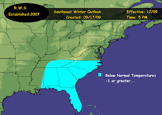

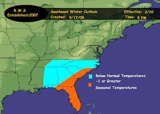
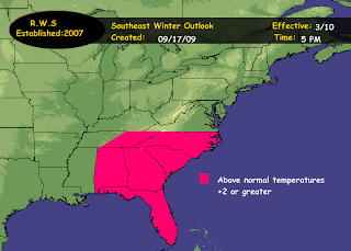
This is the first time that I have ever attempted to forecast the winter for the southeast. Normally I would just forecast for the mid atlantic and the northeast. however...after careful consideration and deliberation..I have decided to expand my weather forecasts across the USA. When it comes to seasonal or long range forecasting, particulary in a new region that was not previously covered its more a trial and error basis forecast that will probably be fine tuned closer to the actual winter. Not quite as familiar with there climatology as I would be the northeast and mid atlantic.
These are my thoughts from the outlook issued for the northeast and mid atlantic and at this point and time i see no reason why they would not be applicable to the southeast as well because it would essentially be the same synoptic setup that is in place..
"Looking at el nino years 1970,1972,1974,1975,1976,1977,1979,1981,1982,1984,
985,1986,1992,1996,1997,2000,2004. Out of the above el nino years..seventeen total, 9 of the 17 winters following a cooler then normal summer..came out colder then average. So this is better then 50% of the winters came out colder then normal.
The above information in combination with the general pattern that we have been in since last winter that I have coined the TZT..I expect to continue thru the winter of 2009-10. Of course, no pattern can stay in place without having breaks in between or relocations of this particular pattern. So there will be times that this pattern of TZT will relaz and or relocate. However..I expect the pattern of TZT to be pretty much dominant thru the winter of 2009-10.
This pattern has been controlled by a pretty strong negative EPO in tandem combination with a negative NAO which has led to some unusual blocking patterns over the summer. This has also led to a central ridge and an eastern trough. This is the pattern I am now pretty much anticipating to continue through out the winter of 2009-10..though with breaks of relaxation in between."
Now, as stated above in the quotes I am expecting the pattern that has pretty much been in place most of the summer to continue thru the winter where that consisted of a trough zonal trough pattern or TZT pattern which was dominated by a positive PNA & negative EPO and negative to neutral NAO. There was relaxation times within this period and those are the months since may where temps have been above normal.
Now in the southeast it has essentially been the same way..May was above normal...a difference comes in the month of June where it was also above normal but July was below normal while august came in split west to east. East above normal while west was below normal..September pretty much is below normal thus far across the region. So i can state with fairly high confidence that the pattern should pretty much continue and with mainly slight variations (as has been compared to further north)
So with that said I am mainly expecting a below normal temperature winter with temperatures minus 1 or greater across the region pretty much december thru february.
Now i did not create a precipitation map at this point and time. On average the SE generally recieves 8 inches or less of snowfall per year. Precipitation I believe is going to be pretty much above normal across the region due to troughiness and an increase in storms tracking out of the GOM and eastward across the region before turning up the coast.
I am expecting an el nino to remain in place but with a peak no greater then weak and its quite possible that this el nino will fade during the winter. Its an unusual El Nino with La Nina like effects part and partial why i feel that the precipitation will be above normal...This forecast can also be found on the blog for Across the USA..
Southeast Winter Outlook 2009-2010


This is the first time that I have ever attempted to forecast the winter for the southeast. Normally I would just forecast for the mid atlantic and the northeast. however...after careful consideration and deliberation..I have decided to expand my weather forecasts across the USA. When it comes to seasonal or long range forecasting, particulary in a new region that was not previously covered its more a trial and error basis forecast that will probably be fine tuned closer to the actual winter. Not quite as familiar with there climatology as I would be the northeast and mid atlantic.
These are my thoughts from the outlook issued for the northeast and mid atlantic and at this point and time i see no reason why they would not be applicable to the southeast as well because it would essentially be the same synoptic setup that is in place..
"Looking at el nino years 1970,1972,1974,1975,1976,1977,1979,1981,1982,1984,
985,1986,1992,1996,1997,2000,2004. Out of the above el nino years..seventeen total, 9 of the 17 winters following a cooler then normal summer..came out colder then average. So this is better then 50% of the winters came out colder then normal.
The above information in combination with the general pattern that we have been in since last winter that I have coined the TZT..I expect to continue thru the winter of 2009-10. Of course, no pattern can stay in place without having breaks in between or relocations of this particular pattern. So there will be times that this pattern of TZT will relaz and or relocate. However..I expect the pattern of TZT to be pretty much dominant thru the winter of 2009-10.
This pattern has been controlled by a pretty strong negative EPO in tandem combination with a negative NAO which has led to some unusual blocking patterns over the summer. This has also led to a central ridge and an eastern trough. This is the pattern I am now pretty much anticipating to continue through out the winter of 2009-10..though with breaks of relaxation in between."
Now, as stated above in the quotes I am expecting the pattern that has pretty much been in place most of the summer to continue thru the winter where that consisted of a trough zonal trough pattern or TZT pattern which was dominated by a positive PNA & negative EPO and negative to neutral NAO. There was relaxation times within this period and those are the months since may where temps have been above normal.
Now in the southeast it has essentially been the same way..May was above normal...a difference comes in the month of June where it was also above normal but July was below normal while august came in split west to east. East above normal while west was below normal..September pretty much is below normal thus far across the region. So i can state with fairly high confidence that the pattern should pretty much continue and with mainly slight variations (as has been compared to further north)
So with that said I am mainly expecting a below normal temperature winter with temperatures minus 1 or greater across the region pretty much december thru february.
Now i did not create a precipitation map at this point and time. On average the SE generally recieves 8 inches or less of snowfall per year. Precipitation I believe is going to be pretty much above normal across the region due to troughiness and an increase in storms tracking out of the GOM and eastward across the region before turning up the coast.
I am expecting an el nino to remain in place but with a peak no greater then weak and its quite possible that this el nino will fade during the winter. Its an unusual El Nino with La Nina like effects part and partial why i feel that the precipitation will be above normal...This forecast can also be found on the blog for Across the USA..
Pacific Northwest & West Coast Outlook For The Week of Sept 17-23rd
An area of low pressure and its associated trough off the Pacific Northwest Coast will begin to move into the Pacific Northwest over the weekend. This will spread cloudiness and showers into the Pacific NW friday night and saturday. Thereafter..the trough will continue to progress to the east and the rainy weather should move east of the region just in time for sunday. Meanwhile the rest of the west coast looks to enjoy fair weather conditions.
After this trough progresses eastwards with its associated rain.. high pressure will build into the region as the PNA spikes positve and the EPO goes negative. This will result in a ridge building across the western area and pacific northwest with high pressure in control. If this were summer time temperatures would approach the high 90s and lower 100s under this setup. However..as a result temperatures will end up being in the 80s across the region.
Along the west coast in California, where generally fair and sunny conditions develop ..temperatures could exceed 90 degrees once this high pressure and ridge builds across the west. So at least in this part of the USA..summer is not over..
Rainfall across washington, montana and parts of Idaho will generally be on the light side from a T to less then .75 inches from the approaching trough and area of low pressure.
September 17th Weather Discussion
Who ordered the Rain & Dreary Weather?
Well, the answer to that is Mother Nature... Todays weather is essentially going to be a cool and from time to time wet day. Especially from SNE and point southwards. With a stalled cold front to the south of the region and waves of low pressure moving across this front this is going to keep that area under cloudy and wet conditions and very cool temperatures once again...
Temperatures across the region are going to be in the 60-70 range and consider yourself lucky if you reach the 70 degree range.. Autumn has started and we are still a week away..
South of PA temperature will be in the lower 70s...
Sept 16th high temperature at KABE was 66 degrees
MidWest Edition For The Week Of Sept 17-23rd
The biggest weather maker across the midwest will be a trough dropping down thru the region from the Northwest. This trough looks like it will start to drop into the region around early to midweek ..Out ahead of this a S/W looks to develop around Nebraska as another S/W develops and drops into the region from the Dakotas. This will start to bring the chance of showers to the region early next week into midweek along with falling temperatures. Temperatures thru the period will range in the 80s across the Upper Midwest early in the period and 70s elsewhere but with the approach of the trough and S/Ws and the associated cold front temperatures will drop into the 60s across the region for daytime highs.
As the time gets closer to this event I will be issuing a rain fall map for the region....
Southeast Weather Edition For The Week Ahead of Sept 17th-23rd
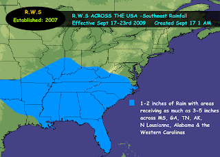
The synoptic weather situation across the Southeast is not going to change all that much thru the week ahead. Persistent area of low pressure located over eastern Tx and Northern Lousianna is not going to move all that much over the next week. This area of low pressure will slowly move off to the east to over Mississippi by the weekend and then eventually dissipate as it starts to get lifted off towards the north due to a strong trough coming into the region over the weekend. This trough dropping southwards from the plains will drag a cold front across the region early next week. The combination of this area of low pressure and approaching trough and cold front will keep showers and thunderstorms across the Southeast thru the week ahead. Very heavy rainfall in the order of 1-2 inches + can be expected..
Meanwhile temperatures across the region will be in the 70s and 80s across the far southeast...
Southeast Weather Edition For The Week Ahead of Sept 17th-23rd

The synoptic weather situation across the Southeast is not going to change all that much thru the week ahead. Persistent area of low pressure located over eastern Tx and Northern Lousianna is not going to move all that much over the next week. This area of low pressure will slowly move off to the east to over Mississippi by the weekend and then eventually dissipate as it starts to get lifted off towards the north due to a strong trough coming into the region over the weekend. This trough dropping southwards from the plains will drag a cold front across the region early next week. The combination of this area of low pressure and approaching trough and cold front will keep showers and thunderstorms across the Southeast thru the week ahead. Very heavy rainfall in the order of 1-2 inches + can be expected..
Meanwhile temperatures across the region will be in the 70s and 80s across the far southeast...
Wednesday, September 16, 2009
A Sneak Peek Preview On ENSO 2010-2011 Winter
Tuesday, September 15, 2009
September 16th Weather Discussion
Rainy Weather On Tap
The following were the high temperatures at KABE from Sept 4th to today the 15th..
Sept 4 80
Sept 5 82
Sept 6 77
Sept 7 73
Sept 8 77
Sept 9 73
Sept 10 67
Sept 11 60
Sept 12 67
Sept 13 78
Sept 14 77
Sept 15 77
Today is going to be a rather chilly day across the region with the possibility of showers as well. Although the whole region is in this chance of showers..the best area for showers will be along the coast from roughly ACY into SNE. I think there is a good chance for interior regions to be mainly cloudy but would not be surprised to see the sun poking out every now and then. Also the chance for showers does exist across the interior.
Temperatures are going to be downright chilly the further north that you go. In MAINE upper 50s to lower 60s. South of PA temperatures in the lower 70s while the rest of the region across the Northeast will be in the lower 60s-lower 70s. Definitely more of a fall like day then a summer like day and this type of weather looks to exist and continue for a couple days as a trough moves across the region with a cold front that will stall to our south...
October 2009 Outlook

The current thinking is that october should end up below normal across the region. This due in tandem to the pattern that we have been locked in since May of 2009. Pretty much a -NAO (to neutral) to -EPO (to neutral) to + PNA (to neutral) ...keeping troughiness along the east and cooler then normal conditions...
Rainfall Sept 16-19th 2009
More Thoughts On Winter 2009-2010
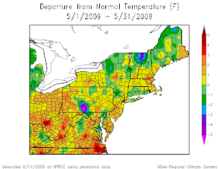
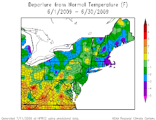

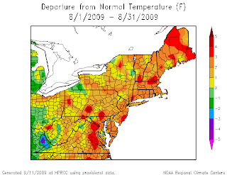
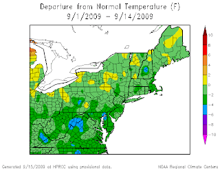
To look at the winter that will be arriving within short time on our doorsteps, I feel its pretty much important to look at what has been occurring over the last 5 months. Pretty much what has been the dominant pattern? What teleconnections have been essentially driving the weather. Basically since May 2009 we have been under a pattern that has been controlled by a Negative NAO (to neutral) a Negative EPO (to neutral) and a Positive PNA (to neutral)..This has been essentially the pattern that we have been being dominated by. This has caused a relatively up and down summer and perhaps one could say more down then up? May 2009 we ended up pretty much above normal temperature wise across the region. There will always be a small area of exception to this rule.
Then along came June and July 2009 ..that swung the pendulum in the opposite direction of below normal temperatures.
However...look what happened again come the month of August..
Another relaxation period had taken place. The temperatures swung the pendulum once again. So this brings us to current time frame..
The pendulum once again has swung back into the pattern that has been established thru out pretty much of the summer. I pretty much have been aware of this pendulum and its swings and have referred to it as the TZT pattern. Expected this TZT pattern to return pretty much around mid september. Pretty much right on time, if not a tad earlier then expected.
This pretty much sets the stage for what should and could occur this winter. Proceeding on this pattern..my calculations would pretty much put September into the below normal category,as well as put October 2009 into the below normal category across the region. We have a relaxation period for the month of November..where temperatures will be above normal. Then back to December & January Below normal. Wash, rinse and repeat.
The EL Nino has not been able to gain any kind of a food hold. It really has been struggling from the get go of its existence. Indexes and teleconnections just do not want to cooperate enough to allow much further strengthening of the El Nino. The call from the beginning of this thread was for a Weak El Nino and i am beginning to think that that is where we will actually peak out at for ENSO State. I think the atmosphere is still feeling some lingering type effects of La Nina and this is also interfering with the El Ninos ability of gaining that foot hold.
If current pattern recognition is correct (both past as well as future) and October does end up below normal across the region..then this winter will be more of a winter for the cold & snow lovers across the region. One potential fly to the forecast is that temperatures could end up being so cold that the air could end up being drier then normal during those months. However, a positive to this pattern is that with the combination of -EPO +PNA -NAO (ridging on west, trough on east) then we would be looking at more storms taking the southern track and riding up the coast. So the potential exists this winter season for more coastal storms then previous winter seasons. If october ends up as thought, then we could be not only talking about cold (perhaps record cold) but we would also be looking at the potential for above average snowfall across the region and the potential for more significant indiviudal snow events.
So thats where i am at this point and time with where we been, where we are and where we are going. Of course I will update this as needed and whenever neccessary..


