
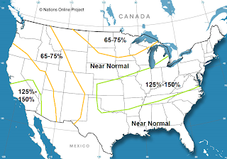
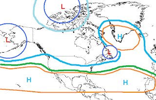
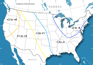
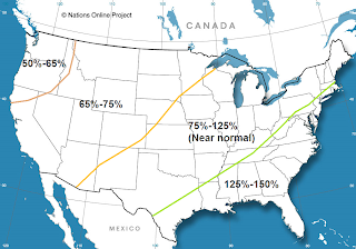
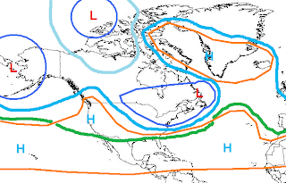

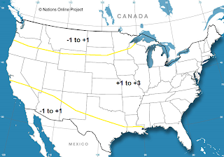

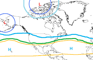
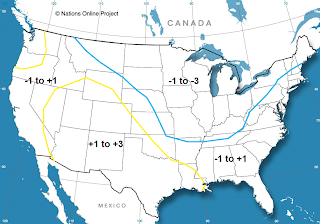



Refer to all images above when reading discussion below :
2009-2010 US Winter Outlook
Alright, before I get into it a few things. First off, this is my first winter outlook ever, so chances are the results may not be what I would like. However, I think I have read up enough on sites like MetEd and have read what mets have posted on weather boards such as eastern for a couple of years now so I think I have at least the basic understanding, and do have to start somewhere.
The outlook is broken down into two main sections. The first one is just trying to get down the main pattern that will set up, especially over the Pacific and trying to pinpoint where any high latitude blocking will be if it happens. The second section is going to try to time things and break them down at least month by month if not a little smaller range if I feel that I can do that.
Pacific Pattern:
The first important thing I’m going to look at is the state of the ENSO, and what it looks like it will try to do from here. Right now we are in a basin wide weak El Nino. There has been some cooling over the last couple weeks, especially over regions 1+2, which are the most variable. This may be in response to the SOI going very positive and the AAM a little bit above normal which promotes somewhat stronger trades. And on top of that, the southern hemisphere is actually looking quite Nina-esq with cooler waters running up the S. America coast with a large polar vortex causing a strong surface high to the west of S. America continuing to cool the waters and funnel them up the coast towards the equator. Also, sub surface temperature anomalies have gone below normal over the eastern Nino regions. So, this leads me to believe that we will not get an east based event.
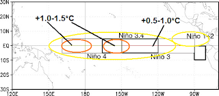
Speaking of sub-surface temps, east of 120W the subsurface temps have cooled, however west of there the waters are warm all the way down. So, the water being upwelled west of 120W will not be all that cold. But, with trades remaining fairly strong for an El Nino event some of the cooler water over the eastern equatorial Pacific near the surface may move west some, so I think areas east of 120W will cool to between 0 to +.5 degrees C, areas between 120W and 160W will cool to +.5 to +1.0, and areas west of 160 N will remain close to where they are now, +.8 to +1.2 as we head into winter. So, the Nino is definitely kind of basin wide right now, but assuming trades can remain somewhat strong and continue to upwell and push some of the colder waters west I think the Nino will become more west based by winter. So, not to copy off of Chuck here but this is what I think the anomalies will look like come DJF within 10 degrees of either side of the equator (outside of there I didn’t look at).
Now, over the northern Pacific…while this may not be quite as important as the ENSO phase it is somewhat important with relation to how strong the PNA is, and where the vortex will set up over the far northern Pac. Over the summer the PDO spiked a bit and did become more neutral, but over the last couple of weeks the waters over the NE Pacific and over the Gulf of Alaska have really cooled, and there is now a large area of negative anomalies over the NE Pacific, with the NW Pacific pretty much a wash with warm anomalies to the north and cooler anomalies to the south.
Now, logic says the Hadley cell over the Pacific will be strongest west of 150W, which is where the best tropical forcing due to warmer waters along the equator is expected to be. This will create a stronger gradient on the northern edge of the cell over the western Pac (west of 150W). This will create more storms in general there and a stronger jet stream over the western Pac. This would probably put a strong upper level low to the northwest of 35N/150W, which happens to be where most of the ENSO/PDO related anomalies I used put it. Farther east over the eastern Pacific and closer to the west coast the Hadley cell shouldn’t be as strong, so the jet will be a bit weaker there. This should allow the upper low (which will probably be in the vicinity of the Aleutians a lot of the times so we’ll just call it an Aleutian low) to at least try to pump up heights some close to the west coast and possibly over western Canada. While the overall configuration/strength of the ENSO related anomalies will be favorable for this setup that would lead to a +PNA/-EPO, the cold waters over the NE Pacific/GOA has me concerned that strong ridging over the western portions of the continent may have at least some trouble forming.
With the cold waters off the NW coast and off of western CA/AK any S/Ws over that region may have a tendency to try to move more southeastward over that area possibly knocking down the ridging on the west coast from time to time. With the Nino not being particularly strong, I’m not sure the Nino induced Aleutian low/-EPO will be overly strong and overcome this, so while I definitely don’t see a large trough on the west coast with a strong flow screaming off the Pacific into the west coast, I don’t think we’ll see S/Ws riding well north into Canada north of a -EPO/+PNA combo and then dive south into the central/eastern US, the pattern may be less amplified most of the time on the west coast.
Now, like I said I did use some ENSO/PDO related analogs. I didn’t focus my whole forecast around them, but mainly because this is my first shot at a long range outlook I did want to plug in some analogs to see if I have at least some sort of a general right idea about the Pacific pattern…for analogs I used the September SST anomalies over the Pacific. Was looking for a weak Nino, preferably neutral or west based, with some sort of a cool pool over the NE Pacific in September. Based on these criteria these were the analogs I came up with:
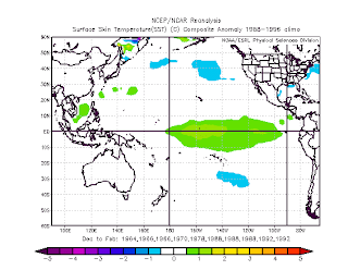
1963-64 (w), 1965-66, 1969-70 (w), 1977-78 (w), 1987-88, 1991-92. Analogs with a “(w)” next to them indicates I think the analog is somewhat useful but a bit weak based on what I was looking for, and gets a weight of 1, analogs with nothing next to them I thought were somewhat better and got a weight of 2, the bold and underlined analog was the analog I though fit best based on Pacific SSTs in September, and got a weight of 3. With that said, here is what the DJF SST anomalies over the Pacific looked like with those analogs:
So, my ENSO forecast was somewhat close to what the analogs show which does give me a little more confidence. The northern Pacific is also somewhat close to what I would envision, so the analogs are giving me the idea that I might be somewhat close.
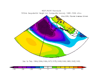
Here is what the Pacific 500MB height anomalies look like with these analogs:(see above)
Alright, so those analogs do show a nice Aleutian low, with as I suspected marginal at best +PNA/-EPO, which may even be weaker because the ENSO the analogs show is a bit stronger than I would expect it to get.
So, in summary for the Pacific I think that as we get into winter a typical west-based El Nino Aleutian low will develop. The Hadley cell will be stronger due to the El Nino increasing tropical forcing along the equator causing a stronger sub tropical jet on the northern side of that. The northeastern Pacific is holding us back some though…I believe with cooler waters over that region S/Ws may have some kind of tendency to drop more SE towards British Columbia or the NW US limiting how amplified any +PNA could get. Overall this would result in a less amplified pattern over the western US, and this may cause S/Ws to phase with the subtropical jet a bit west for the east coast’s liking, but I don’t think the Pacific will really hold us back, hopefully at least. I don‘t think we‘ll get a raging +EPO that floods the continent with warm air. The Pacific is kind of neutral, and the quality of this winter may depend more on high latitude blocking to amplify the pattern, which I’ll get to next.
Atlantic Side/High Latitude Blocking:
I know other mets have done this before, but I’m trying to keep this outlook my own work as much as possible. So, I’m going to plug in analogs that ended up with a -NAO to get an idea of what the September and then DJF SSTs looked like to see if that gives us any clue to what the SSTs could give us this year.
-NAO Sea Surface Temperature Anomalies:
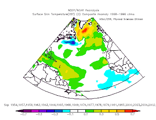
September SSTs:(see above)
A couple of things that stand out…
1. Warmer SSTs up over the NAO region which really shouldn’t be much of a surprise.
2. Cooler SSTs down close to the equator.
Resulting DJF SSTs:(see above)
Not very surprising again, warmer temps over and just south of the NAO region, and near normal to slightly below normal water temps closer to the equator.
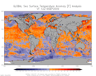
Now, as we look at the current sea surface temperature anomalies on the Atlantic side:(see above)
Right now, the water temperatures over a lot of the northern Atlantic are below normal, but it is important to note that water temperatures surrounding Greenland/Iceland are above normal and those positive anomalies are trying to expand some. So, the current pattern up there may not favor a -NAO right now but it might be getting there. Also, the equatorial temperatures in the Atlantic are slightly below normal. This favors weaker tropical forcing in that area which favors a weaker Hadley cell over the Atlantic. I’m just going out on a limb here, but I would guess that if the cell is weaker, the pressure gradient on the north side of it will be weaker, so the polar jet over the Atlantic come winter will not be as strong. This may favor somewhat warmer heights being pumped northward if the jet is weaker and has an easier time amplifying. So, the sea surface temperatures on the Atlantic side may be somewhat favorable for a -NAO, especially along the equator, along the cooler temperatures over a lot of the northern Atlantic may be somewhat of a limiting factor, but things like a weaker Hadley and stratospheric warming could overcome that fairly easily.
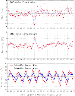
QBO/Possible Stratospheric warming:(see image above)
Right now the QBO is going into the easterly phase, as there are negative anomalies showing up at 30MB, and the 50MB winds are starting to level off and weaken as well. Positive zonal wind anomalies are indicative of stronger westerly winds in the upper atmosphere and negative anomalies indicate easterly winds in the upper stratosphere. As you can see, at the 30MB the winds have become easterly, and at 50MB the positive anomalies are becoming weaker and soon will become negative, or easterly winds, thus we are heading into the eastern phase of the QBO as the easterlies propagate downward.
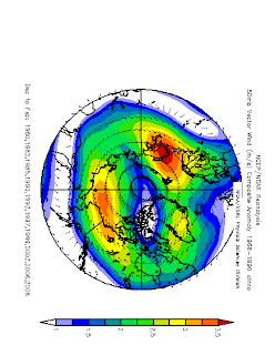
So, what does this all have to do with winter in the northern hemisphere, more specifically the AO/NAO. Well, if the QBO is negative or in it’s “eastern” phase it promotes a weaker or displaced polar vortex. A polar vortex often makes it harder to get sudden stratospheric warming events that could translate to a -AO/NAO. But, a weaker or displaced polar vortex makes it easier to see stratospheric warming events which can often translate to strong high latitude blocks. Just to show what an easterly QBO can do, notice these 50mb wind anomalies over the arctic regions:
Note that the winds are a few m/s weaker than normal. They show up as easterly anomalies, because the winds aren’t as strong from the west as they normally are with an easterly QBO. Now, the polar vortex is still there, but as shown above it is just weaker which makes it easier to see stratospheric warming events:
So again, the PV is usually still there.
But, what this all means is that if we can get something to induce stratospheric warming such as some solar “activity” it shouldn’t have a hard time getting that to happen with a QBO that is going more easterly. Right now the easterlies are still somewhere between 30-50MB, so it will take a little while for them to propagate down to the point where they have the most impact on stratospheric temperatures. It may not get very favorable until January or February, but by the end of winter the QBO will be favorable for stratospheric warming. With a weakened Hadley cell any sudden stratospheric warming event could translate down to a high latitude block or -NAO/AO. If we can get cycle 24 to actually and become somewhat active sometime soon we could have some solar induced sudden stratospheric warming events especially during the second half of winter. So, I think the odds of getting a good -NAO/AO block for at least some period of winter, especially during the second half are fairly good with cooler waters over the equatorial Atlantic and half decent prospects for a sudden stratospheric warming event.
Preliminary NAO forecast:
December: Neutral to positive
January: Neutral-positive becoming more variable with a potential -NAO especially as the month goes on.
February: Variable but the potential for a -NAO block, possibly a strong one seem high. Should average out to be a -NAO month if I’m correct.
This may not work out but here is my NAO guess:
So, what this all boils down to…(see above)
Forecasts by month:
December temp anomalies: (see above)
December precip anomalies:(see above)
December overall 500MB pattern:(see above)
So, in summary…I believe the pattern in December will be somewhat flat. There could be some sort of an attempt at a +PNA but with the NAO probably not being very helpful and a somewhat flat pattern off the Pacific there won’t be any great sources of cold air, so a lot of the CONUS will probably be above normal temp wise for December. With a strong STJ and a possible storm track from the southern Planes through the OV into the upper M.A. (could see a Panhandle hook or two especially first half of the month, if we can find a way to amplify the pattern a little) there will be some areas that see above normal precip, especially along the aforementioned storm track. During the second half of the month could see some sort of MJO induced heavy rains along the west coast and possible warmer weather over the eastern half of the nation, possibly the SE ridge briefly flexing its muscles at this point.
January (see images above)
I really think this month will be atypical for an El Nino, mainly due to the PDO and cold waters over the NE Pac/Gulf of Alaska. I do think we’ll see some kind of an Aleutian low with maybe an attempt at some sort of a +PNA, but I think the colder waters will cause S/Ws to come in and knock down any ridging over the west quite a bit. This will cause the cold to end up farther west than your normal El Nino with a +PNA/EPO configuration would give you. Now, later in the month I think the NAO will attempt to go negative, and we could see a good 50/50 and -NAO combo for some point at the end of the month. This could shift the cold and storm track east closer to the Mid Atlantic by the end of the month so I will not put any positive temp anomalies there, although the first half of January could well be cool/wet/stormy over the lower GLs/OV/New England and warmer and somewhat drier over the Mid Atlantic/southeast because the northern branch will be getting too far south too far west, and if we get an active southern branch with a neutral NAO like I think we’ll see the first half of January, any storms will phase rather far to the west and head up into the Apps or even lakes. So, quite frankly January, especially the first half could end up looking somewhat Nina-esq with the cold/snow back closer to the Midwest with the northeast ending up rather mild.
If we get a negative NAO to try and form during the second half of the month, the storms could stay a little to the south and the northern Mid Atlantic and the southern portions of New England could get in on some snow then. Slow start to the winter for sure for the Mid Atlantic, southeast, and even SNE if I’m correct here.
February (see images above)
Alright, this month could be a lot of fun. I think the key here is the Pacific. I have pretty decent confidence in the NAO and possibly AO taking a nose dive and staying negative for a lot of the month of February. The key is if the freakin Nino can flex it’s muscle and maybe cause some sort of a +PNA despite the colder waters over the G.O.A. I think that after a few months of the G.O.A being east of a decent Aleutian low, we may finally be able to build the heights enough to maintain half decent ridging over the west. If we can get this western ridging, the eastern 1/3 to ½ of the CONUS freezes. If we still can’t get decent western ridging for whatever reason, I think the cold is less severe than what I show above and probably a little farther west.
If we can get the +PNA to coincide with a -NAO this month, I think the storm track will be just off or possibly along the east coast. I think we may have trouble seeing a large +PNA ridge that forces storms to track far east, like along the 40/70 benchmark, but more like along the coast, which may keep the immediate coast from freezing this month. Now, if the +PNA is even weaker than I’m thinking or even doesn’t come to fruition, again this month is probably a lot less extreme and everything gets shifted to the west. Now, with a potential very negative NAO this month, possibly coinciding with a +PNA and enhanced STJ, if we do get a triple phaser, it would either be in February or early March, at least IMO. The pattern I show is probably amplified enough for one if we get a rather potent piece of energy to come diving in on the polar jet. Now, for this to happen we would first need to get my forecast 500MB pattern to verify, and then actually get a very strong S/W to come screaming down and then phase with the subtropical branch and pull the arctic branch in. So, the odds of this happening are still somewhat low but are definitely higher than most years. Triple phasers do only happen once every 10 or so years in the US, just for some background on how rare they are.
So, if I had to summarize this winter in like one sentence, I would say: Starts slow in the east, but ok in the lakes, but by winter’s end the west is warm, east is cold, and lots of storms will probably be seen.
I did bat around the idea of if I wanted to do this or not…but I will attempt a DJF overall snowfall anomaly map (% of normal, as are all of the precipitation anomaly maps):(image above)

No comments:
Post a Comment