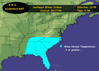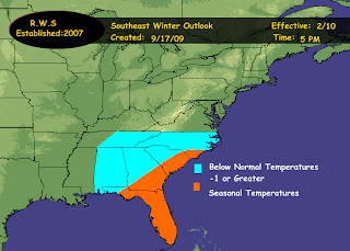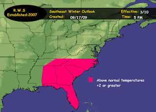


This is the first time that I have ever attempted to forecast the winter for the southeast. Normally I would just forecast for the mid atlantic and the northeast. however...after careful consideration and deliberation..I have decided to expand my weather forecasts across the USA. When it comes to seasonal or long range forecasting, particulary in a new region that was not previously covered its more a trial and error basis forecast that will probably be fine tuned closer to the actual winter. Not quite as familiar with there climatology as I would be the northeast and mid atlantic.
These are my thoughts from the outlook issued for the northeast and mid atlantic and at this point and time i see no reason why they would not be applicable to the southeast as well because it would essentially be the same synoptic setup that is in place..
"Looking at el nino years 1970,1972,1974,1975,1976,1977,1979,1981,1982,1984,
985,1986,1992,1996,1997,2000,2004. Out of the above el nino years..seventeen total, 9 of the 17 winters following a cooler then normal summer..came out colder then average. So this is better then 50% of the winters came out colder then normal.
The above information in combination with the general pattern that we have been in since last winter that I have coined the TZT..I expect to continue thru the winter of 2009-10. Of course, no pattern can stay in place without having breaks in between or relocations of this particular pattern. So there will be times that this pattern of TZT will relaz and or relocate. However..I expect the pattern of TZT to be pretty much dominant thru the winter of 2009-10.
This pattern has been controlled by a pretty strong negative EPO in tandem combination with a negative NAO which has led to some unusual blocking patterns over the summer. This has also led to a central ridge and an eastern trough. This is the pattern I am now pretty much anticipating to continue through out the winter of 2009-10..though with breaks of relaxation in between."
Now, as stated above in the quotes I am expecting the pattern that has pretty much been in place most of the summer to continue thru the winter where that consisted of a trough zonal trough pattern or TZT pattern which was dominated by a positive PNA & negative EPO and negative to neutral NAO. There was relaxation times within this period and those are the months since may where temps have been above normal.
Now in the southeast it has essentially been the same way..May was above normal...a difference comes in the month of June where it was also above normal but July was below normal while august came in split west to east. East above normal while west was below normal..September pretty much is below normal thus far across the region. So i can state with fairly high confidence that the pattern should pretty much continue and with mainly slight variations (as has been compared to further north)
So with that said I am mainly expecting a below normal temperature winter with temperatures minus 1 or greater across the region pretty much december thru february.
Now i did not create a precipitation map at this point and time. On average the SE generally recieves 8 inches or less of snowfall per year. Precipitation I believe is going to be pretty much above normal across the region due to troughiness and an increase in storms tracking out of the GOM and eastward across the region before turning up the coast.
I am expecting an el nino to remain in place but with a peak no greater then weak and its quite possible that this el nino will fade during the winter. Its an unusual El Nino with La Nina like effects part and partial why i feel that the precipitation will be above normal...This forecast can also be found on the blog for Across the USA..

No comments:
Post a Comment