Monday, July 19, 2010

A New R.W.S Area of Interest In the Eastern Atlantic

wv-l

Something to keep an eye on over the days ahead.

July 19th Severe Weather Potential

CAPE 1000-2000

LI-2 to –8

Mid Level Lapse rates 5.5-6.0

Shear around 30 knots

Temperatures in the 90s

Trigger: Advancing cold front and pre frontal trough.

Cons to Severe Weather Potential

Clouds and subsidence left behind from clusters of showers and thunderstorms that are in C PA and progressing east ward as of 4 AM

Severe Hazards Expected:

Damaging winds

Possibility of Hail

Heavy Rains

719

July 19th Daily Weather Discussion

July 18th high temperature @ KABE was 89 degrees. This was about 3 degrees compared to normal.

Today is going to be a partly to a mostly cloudy day though there will be times of sun as well. There is also an advancing cold front working its way towards the region and this should cross the region sometime in the afternoon hours. Out ahead of this front will be showers and thunderstorms and some of those storms could contain gusty winds and heavy rain along with the possibility of hail as well.

Temperatures today are going to be in the 70s to the north, 80s in between and 90s to the south.

For severe weather specifics please see the next post which should be completed in the next 30 minutes

Sunday, July 18, 2010

NHC Agrees With RWS and Highlights New AOI

As of its latest update, NHC decides to highlight the AOI, RWS had highlighted a bit before NHC's latest update.

Below is NHC's newly highlighted AOI:


Notice: Image can be found on NHC site.

New RWS Area of Interest - AOI #2

As of 00Z/8PM RWS has felt the need to highlight a new area of interest besides the current AO1 #1 located near Puerto Rico.

AOI #2 is producing continued thunderstorm activity and is located in a upper level environment that is conducive for further develop as shear ranges between 5 and 10 knots and is expected to decrease by as much as 10 knots. Aside from that, water vapor (moisture) profile is good as well as upper level divergence and low level convergence, which would allow for good breathing dynamics for outflow formation and continued thunderstorm activity. As for 859mb vorticity, it's not that good as there seems to be no low level circulation. Therefore, although upper level environment and surface environment are conducive for development as of now, the lack of a low level circulation center, implies that development should be slow to occur. Besides the parameters aforementioned, very favorable MJO in phase 2, allows for continued upward motion, which enhances thunderstorm activity which further would serve to aid in any possible develop of AOI #2.

Below are displayed the NHC Rainbow IR and Water Vapor satelite images: (Both display RWS's new area of interest.

NHC Rainbow IR:


Water Vapor:


Notice: Images can be found on the NHC site on its satellite page. Original images do not have drawn red circles.

Current AOI #1 (Near to Short Term Setup)

Tropical Atlantic Basin: Caribbean
(Written and analyzed by RWS member Carlos [OmegaBlock]

As of Sunday July 18th @15:30Z/11:30AM, RWS official AIO (Area of Interest), which is located just to the E and NE of the Windward and Lee
ward islands, has been officially highlighted by the NHC since its 8PM EDT update last night, as it can be seen below:


Given the current favorable state of the MJO, which is in phase 2, plus a host of at least decent upper level parameters including upper level divergence, low level convergence, not perfect but decently bundled 850 vorticity energy, lack of SAL and, at least for the short term, decent to good water vapor (moisture) levels ahead of the official RWS and NHC AIO. However, there are two possible limiting factors and a third one, which would depend on the AIO's track. The short term limiting factors, would be current shear levels due to the ULL (Upper level low) located to the NE of Puerto Rico and possible drier air profile towards the central Bahamas due to lower levels of water vapor.

  • The first limiting factor, the shear cause but the ULL to the NE of Puerto Rico. is always a bad factor to any tropical cyclone candidate. In this case, short term current shear profile forecast displays 20 to 30 knots of it, affecting the system as it gains latitude and track WNW towards Puerto Rico. However, the shear tendency forecast, implies it should dimish by as much as 10 knots, which would bring the shear down 10 to 20 knots, making the short tern shear profile much more bearable and somewhat better for organization of AIO #1.
  • The second limiting factor would be the area of drier air around the central Bahamas area due to a lower level of water vapor (moisture profile) over there. This may be an eventual issue in case the moisture profile there does not become better to increase water vapor levels and AOI #1 tracks there as it may happen given the depiction shown by the current 250-850mb and 500-850mb steering currents.
Concerning the track of AOI #1, the current 250-850mb and 500-850mb steering currents profile, implies a track WNW for the most part for the near term and then a more NW track on the short to medium term, which would take AOI#1 right over Puerto Rico or just to the north of it, and then towards the Bahamas on the medium term. Therefore, due to a possible track over Puerto Rico during the near to short term, the third potential limiting factor becomes known; land interaction. Such limiting factor, would have some impact on the AOI #1, it should not be a big problem, as the Puerto Rico is not a big land area and the system is not very much organized or even closed off. Below follow the current 250-850mb and 500-850mb steering currents.

250-850mb steering currents:


500-850mb steering currents:


Below follow other important p
arameter images related to AOI#1 which were mentioned on the text above: (AOI #1 location and immediate surrounding parameter conditions)
Water Vapor IR: Current Shear:


Low Level Convergence:


Upper Level Divergence:


Current Shear:


Current Shear Tendency:


850mb Vorticity:


Assessment: An increase to 20% of AOI #1 chance of development into a tropical cyclone, may be in order for later updates still today by RWS, which would turn AOI #1 into Invest 97L. NHC may follow suite in its updates for today and into tomorrow, by increasing the chances for development to 20% as well and officially turn AOI #1 into Invest 97L, as well.


Notice: All images used are found on the CIMSS site, with the exception of the water vapor image which can be found on the NHC site on the satellite page.

Tropical Update July 18th 2010

With just twelve days to the end of the month..and 42 days into the tropical season…the total named storms stand at 1. That was Alex. Alex happened when we were in Phase 2 of the Madden Julian Oscillation. We find ourselves in Phase 2 of the Madden Julian Oscillation once again as this chart clearly shows.

phase.Last90days

So does this mean that we could potentially be on the way to seeing a system develop into Bonnie? Well, the answer to this goes a little deeper then the MJO.If one were to look back at the time frame around Alex ..you would find that we had quite a few tropical waves that became invests but due to shear in place around the invests they really did not develop, with the exception of Alex and TD2.

With this MJO phase…despite it being in a favorable location we really have not been able to get any tropical waves to even be classified as invests. Dry air was not a problem back around and before Alex. So dry air at that time was not a culprit because it was not even a factor. However, I strongly think the shear was and just climatology at that time. However, this go around SAL/dry air has become an issue and shear continues to be an issue, especially off the coast of Africa.

So lets take a look around the tropics today. On our tour of the tropics the first place we are going to look at is the Atlantic.

awv

When we look at the wide view of the Atlantic …there are three features that stand out. The first feature is the orange color in the water vapor and that represents the SAL invasion. The second feature that stands out is the Upper level low that is to the north of the Antille Islands. The third thing that stands out (you may have to put the image into motion is the ULL near Florida. Other then these two features the Atlantic is quiet.

Next stop is the Gulf Of Mexico!

wv-lgm

As you can see in the GOM there is nothing going on as far as tropical is concerned and around Southern Tx you can also see some dry air in that region of the GOM waters.

The next stop along the tour of the tropics is going to be the eastern Atlantic which will also show the African coast.

EA

Here we see some waves coming off the coast of Africa. However, if you put this image into motion for the most part you can see these waves are basically being shredded apart. You can also see some dry air across the region as well . The following two images are going to show why these waves are getting ripped apart.

splitE

The above image is the SAL. This is actually the second episode of what should be three episodes of SAL. The third one you can actually see back across Africa. This SAL will not let up as long as the 500mb heights remain extremely high over Africa  and Southern Europe. However, the SAL is not the only concern on this end..

wm7sht

The increase in shear is also a high concern across this part of the Atlantic. So as you can see there are two main factors in place on this side of the Atlantic. SAL & shear increasing.

This brings us to the final part of the tropics which would be the Caribbean.

wv-l

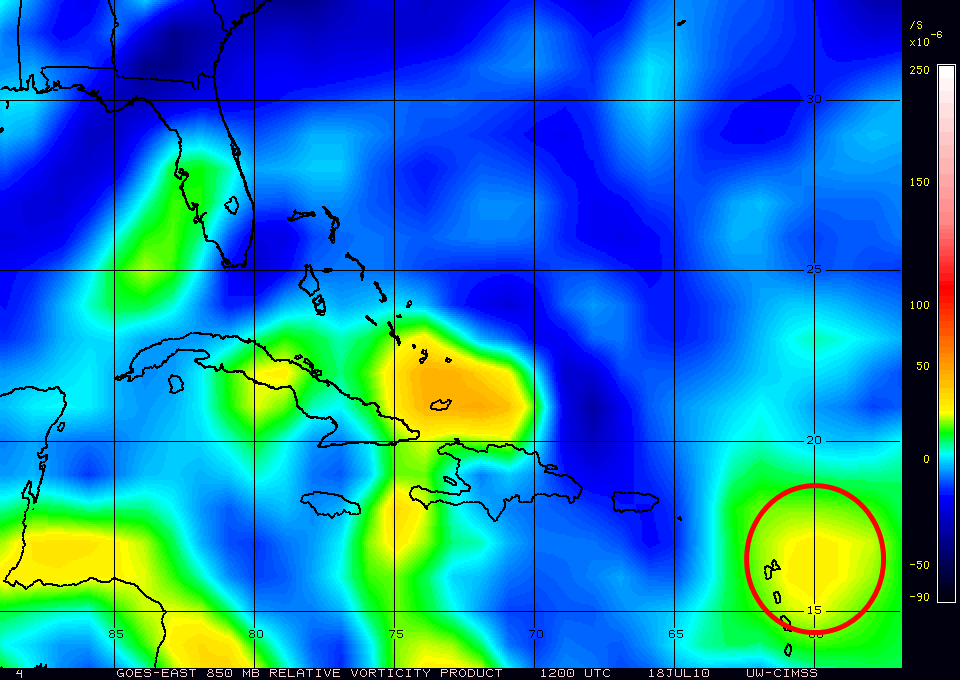
The area circled in yellow is R.W.S Area of Interest since yesterday afternoon. At the moment this AOI is not looking all that well and is surrounded by dry air. Another potential problem is its proximity to land and also the influence of the TUTT or ULL. If it is able to survive these factors and make it into the Caribbean then there is a chance that this could actually develop with the MJO being favorable.However, at this point and time conditions and upper level winds are not really favorable for any type of development.

So that wraps up your tour around the tropics and other then the R.W.S AOI ..the tropics are rather quiet and uneventful. Outside of the AOI above ..the tropics should continue to remain on the quiet side but we will continue to track any tropical waves and highlight potential development AOI’S.

Look for this to be updated later tonight or Monday night if conditions warrant it.