Thursday, December 31, 2009

Special Statement Update Jan 1 /2010

Time 2:25 PM

Issued: Dec 31/2009 

Currently there is a lull in precipitation across the region. After anywhere from 2.6-3 inches of snow has fallen ..Left over energy is organizing itself over WV and will rotate thru the area this evening and overnight and tap into some atlantic moisture. Snow will once again over spread the area this evening and potentially lay down another 1-3 inches across the region on top of the snowfall that has already occurred. 

This statement covers the PHL burbs all of east central PA into NW NJ into NE PA. 

Due to this Real Weather Services has decided to keep the winter weather advisory in place.  This statement will expire at 7 AM -Jan. 2nd 2010

January 2010 Monthly Outlook


Look for some specifics soon to follow this post..over the next day or two!

Final New Years Eve Storm Map

Wednesday, December 30, 2009

Final Call (Dec. 31/Jan. 1-4) RYAN

Ryan: RWS Team Member

Storm: December 31/Jan 1-Jan 4

Type of Storm: Winter Storm

Format: S/W (1/2)

Scenario: As a S/W developing in the GOM heads NE/NNE into the SE US, it is spreading moisture currently in the form of rain up through the Miss. Valley. This storm will continue on its trek NE delivering Wintry Precipitation into the MA/NE areas. There has been the idea floating around that this is a two wave system. That is correct. The first wave will be the one responsible for most of the accumulations south of NY state. The second wave on the other hand, will track up the EC after coming off of the NC coast and head into Nova Scotia spreading precip into the NNE. After that, there is a likelihood that it will retrograde into the Gulf of Maine spreadin an extended period of SHSN through the NNE/parts of the SNE as well.

Models: Models have been all over the place in the past few days, so the format of forecasting I used for the discussion and analysis is a Nowcast. It seems to be the best way to go. Precip that has developed over the SE which was originally progged to track a bit more to the SE will impact areas in the Mid-Atlantic. This will not be much of a significant storm south of the CONN/RI Area, or for anyone south of NY state.

Areas Affected: MD/DE/PA/NJ/NY/VT/NH/CT/RI/MA/ME

Possible Room for Error: I along with the other members of RWS are watching a potential change in track since this storm was never perfectly depicted on the models. I will update if I see anything suspicious in the radar, steering currents, or water vapor imageries as storms can sometimes deliver surprises.

Headlines: Matt issued a RWS WWA for some areas earlier today.

Maps: I have the overall forecast map and individual state maps for MD/PA.


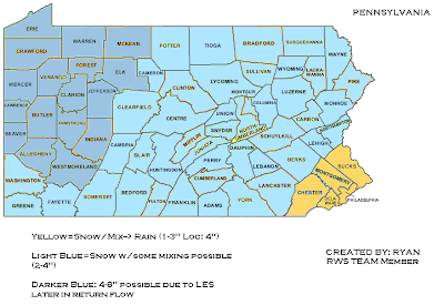
Timeline (for start of precip):

Washington DC/Baltimore: 3-4 AM Philadelphia: 7AM NYC: 11AM

Boston: Friday Morning(S/W #2)

Hello, I am Ryan and I am a new member of the RWS solutions team from Dundalk, MD. I love the site and am honoreed to be a part of something great.

New Years Eve Snow Potential


Time: 4:10 PM 

Winter Weather Advisory

This winter weather advisory is in place from 12/31/09-1/1/10 


Real Weather Service has issued a Winter Weather Advisory for all of SE PA , All of East Central PA all of Northeast Pa and all of Northwest NJ.

Low pressure currently getting itself organized over the GOM will continue to spread moisture off to the Northeast. This area of low pressure will continue to move off to the NE and be in a position off the delmarva by thursday afternoon. This low pressure will cause overrunning moisture to move into the area after midnight tonight. With surface temperatures around freezing and 850s cold enough ..This should support a mainly snow event across the regions mentioned in this Winter Weather Advisory. 

Early total snowfall accumulations look to be along the range of 2-4 inches. There is a possibility that the area could be looking at more ..however..there is too much uncertainty at this time to hone in on that and this will have to be re addressed with later statements! 

Please stay tuned for any further updates including potential watches and or warnings.

A winter weather advisory is issued when snow/sleet and or freezing rain is expected to impact the region.

Monday, December 28, 2009

Jan 1st-3rd Snowfall Potential


Scenario Map * Will change when first call map is issued 

Friday, December 25, 2009

Christmas Day!


Merry Christmas to everyone!

To the weather its not getting as cold tonight as forecasted to become. Was suppose to go down to 23 degrees but we have only made it down to 27 degrees. Cloudy skies are across the area.

Low pressure is located over eastern missouri...

Radar shows a tremendous amount of moisture associated with this system...

With the warm air aloft basically expecting a total ice scenario versus snowfall at least at the beginning of this system. Ice accumulations will be relatively on the light side with only about .10-.15 but thats enough to make things slippery when traveling. Generally expecting majority of the region to turn over to plain rain.

Thursday, December 24, 2009

Update Scenario for X Mas Day 2009


Questions that still need to be answered...


Temperatures and dewpoints?
Does a secondary form and if so where?
How strong is the high pressure to the north?

However..perhaps the biggest question is how much QPF actually makes it into the region?

I think at this point is the biggest unknown... Not only is how much QPF makes it into the region while the temps are supportive of frozen but how much over all QPF?

How much WAA will there be if the majority of the precipitation rides west of the region and then we are only dealing with QPF from the potential coastal low?

Unfortunately all these might come down to the last couple hours before the event...

On this map I believe Pittsburgh PA will start as brief ice and go to rain and then change back to snow later in the period..same thing stretching up towards Erie Pa...

Tuesday, December 22, 2009

December 25th-27th Storm Potential


Preliminary Scenario Map Subject to change


Friday, December 18, 2009

Unbelievable Satellite Photo of the this Storm!

Photobucket

RWS Issuing A Winter Storm Warning for Dec 19-20

R.W.S  is issuing a Winter Storm Warning for all of SE PA into East Central PA into NW NJ...as well as NE PA. A Winter Storm Warning is issued when a Winter Storm is expected to effect the area within the next 24 hours. 

Low pressure currently over the the Gulf Of Mexico, just south of Louisianna will continue to track off to the NE and end up along the coast of Cape Hatteras. This low pressure, once hitting the gulf stream will deepen and slowly move up the coast. Snow will spread into the region from south to north sometime after midnight. The snow will be heavy at times saturday and saturday night! 

This storm has the potential to deliver a very heavy snowfall across the region. Significant accumulations are expected. 

Current observations show this area of low pressure stronger then modeled and also the precipitation shield further north as well. 

R.W.S will issue a final map early this afternoon after the next model runs come in. Please make plans accordingly. 

This statement was issued at 5:15 AM

Thursday, December 17, 2009

December 19-20th Snow Storm for the Mid Atlantic into the NE


Preliminary Map & I have only issued for MD & North at this point.

The top analogs for this storm are Feb 83, Jan 96 and Feb 03

Monday, December 14, 2009

December 14th Daily Weather Discussion

Since I have the time I am going to resume this. During pre hours of winter storms and during winter storms this will not be updated. Instead see the thread relevant for the weather for those events..

December 14th Daily Weather Discussion

A Potential December to Remember or?
The following have been the high temps at KABE since december 6th to Present

6 34 21 28 -7
7 35 21 28 -7
8 41 26 34 -1
9 40 32 36 2
11 27 16 22 -12
12 37 15 26 -7
13 38 20 29 -4
The last @ in the column is departure from normal. 2nd last # is the average...

Today should be a partly to mostly sunny day once the fog and some clouds move out of the area.

Temperatures will range in the upper 20s to upper 30s in Maine and in the Mid 30s to mid 40s thru out the rest of the region with the exception of south of PA in the lower to mid 50s.

Sunday, December 13, 2009

Dec 13-14th Final Call


Weak low pressure is down along the Tx/ LA border. This low pressure is not very organized nor very strong. The precipitation is out ahead of the low. Commonly called as over running. This over running is essentially being caused by WAA. As this moisture over runs the area majority of the region is at or below freezing and in some cases well below freezing. Currently high pressure is sitting along the east coast which is going to produce a wind out of the south. This WAA is going to cause the 850s to lift above freezing . However for a period of time which i will specify as unknown..the surface will remain below freezing. It just all depends on two things. Surface temperature & how long the CAD can stay in place
The area in Red is primarily going to be ZR and sleet but could start off as a period of snow that could leave a T-1 of show. Further into NE PA potential for an inch or two of snow but even there should end up changing to sleet/ZR..Eventually all areas should change to rain that are in the red zone.

Saturday, December 12, 2009

December 13-14 2009 Rain & Snow!


In between the lines it may start off as frozen depending on how fast the precipitation arrives. However...storm looks to last about 10 hours or less in duration and am expecting a quick transition to rain with the exception of your highest elevations. If the precipitation arrives in fast enough to allow for frozen ..at the most would be looking at T-2 inches.

Things that I was watching last night such as the high pressure..For quite sometime there were two areas of high pressure but that one area no longer exists and the other area is moving east off the coast. The colder scenario would have only existed IF we could have kept both those high pressures in place and moving Northwards.
So essentially expect rainfall with areas along the coast getting .50-1 inch possible
Further inland expect a potential wintry start transitioning to rain with .25-.50 possible

Wednesday, December 9, 2009

Dec 9th SnowStorm Videos

Thus far for the month of December we are 6 inches above normal snowfall in ABE..


Dec 9th-10 Final Update


Just getting around to posting this now


Tuesday, December 8, 2009

December 9-10 Winter Storm


Probably one of the more harder preliminary maps that I have ever had to made for an event. This one took quite a while to make..

Low pressure is currently developing over the SW and that low pressure should continue to move off to the east and eventually turn to the NNE. By wednesday 6 Z this low pressure should be over Southern illinois. Meanwhile another area of low pressure will be riding up the eastern seaboard.

WAA will break out well in advance of this dual low pressure scenario and spread a variety of weather into the region. Anchored to the north of this system will be a high pressure in the range of 1028-1030 mbs and this will provide colder air to anchor in and take hold for awhile. Cold air Damming will effect areas from PA north..however at this point I am not sure if the CAD will be strong enough to reach south of PA. This high pressure will start to lift off to the North and East and as it does so should change precipitation over to all rain in the red zone during the morning on wednesday. The only exception to this will be in the red zone from VT ENE into Maine where it could potentially stay all frozen..

With that all said , before this does changeover to rain its generally going to make the morning rush hour a mess in majority of the NE from PA north.
Again this is preliminary...

Areas not completely sure about are south of PA into western MD..So for those in that area take that part of the map with a grain of salt...

Monday, December 7, 2009

First WideSpread Snowstorm of the 2009-2010 Winter Season

Dec 9th-11th Special Weather Statement

Time 2 PM EST

12/7/09

The following is a special weather statement issued by R.W.S. 


Low pressure currently over the west coast is going to be moving eastward over the next 24-36 hours. This low pressure will be in the ohio valley by about wednesday 12 Z. This low pressure will then move off to the NE but before doing so will develop a secondary over the Chesapeak Bay region. Together these two low pressures will move off to the NE and bring a variety of weather across the region.

This special weather statement applies to all of PA with the exception of SE PA around the PHL area & this also applies to NW NJ.

As the two low pressures move northeast a cold air mass will be in place thanks to high pressure over the northeast. This high will begin to lift into Eastern Canada which will allow this storm to move Northeast. Cold Air Damming will be in place and with precipitation overspreading the area from the south west , look for snow to develop tuesday evening across the areas covered by the statement. The snow may accumulate a few inches before a changeover to ice and then potentially plain rain.

Stay tuned for potential advisories, watches & or warnings on this latest winter storm.

Dec 9th-11th Winter Storm Potential


Alright..here is the scenario map that I mentioned I would put together..

The blue region in PA and southern NY is where you can expect to see snow begin spreading into the area sometime tuesday evening. These areas should mix with and change to ICE potentially before changing to rain on wednesday. Though we will have to see how long the CAD hangs on and should know this better by later this evening. The pinkish/red color is primarily where ICE may occur and could start off as a period of snow..These areas will also change to rain.. The area above the black like is generally where the precipitation should stay all frozen..Primarily snow but its possible that some locations will also change to ICE. This will be clearer later in the evening as well..
Stay tuned for potential Special Weather Statements from R.W.S

Sunday, December 6, 2009

December 6th Daily Weather Discussion

December 6th Daily Weather Discussion

December 4th High temp was 48 degrees @ KABE
December 5th High temp was 40 degrees @ KABE with 3.7 inches of snow

Another storm brewing. Will it be Rain, Ice or Snow or all three?


Today will generally be cloudy to start the day across PA but will be clearing during the day. Further to the north in parts of the Northeast, NY State and north snow showers are still possible and some steadier snow into Maine associated with the low pressure that moved thru yesterday and brought the first pre winter widespread snow storm.
Temperatures will generally be in the 30s to around 40 thru out the region! So if you have any outdoor activities planned..bundle up for its going to be cold.

Saturday, December 5, 2009

R.W.S Winter Weather Advisory

The following is a special weather statement issued by Real Weather Services

12/05/09 2:20 AM

Effective 12/05/09 

Time: 12 noon till 1 AM 12/06/09

The following is a Winter Weather Advisory effective for East Central PA and NW NJ , as well as SE PA. 

Low pressure developing over the Southeast early this morning will continue to lift off towards the North and Northeast and should be in off the Southern New Jersey Coast by 00z Sunday. Precipitation associated with this area of low pressure will start to develop across the southern regions in the early morning hours. Around PHL..it should start out as rain but transition to snow as the day wears on. To the North and West (immediate burbs) there will be a mixture of rain and snow becoming all snow by early afternoon and the far Northern Suburbs should begin as all snow around Noon. Precipitation will begin to taper off by around midnight.

Total accumulations will be in the range of 2-4 inches with some locations receiving as high as 6 inches ..primarily North and West of the city of Philadelphia.

Stay tuned for further updates, watches or warnings if needed!

December 5-6th First Wide Spread Snow Event


Low pressure that is currently over the Southeast in particular the SW Gulf of Mexico is going to basically ride up the eastern seaboard in a projected path of NNE to NE.. to a point where about 06 Z Sunday it will be off the southern New Jersey coast. Since this storm is coming from the GULF area its going to be bringing a good amount of precipitation towards the region. The question becomes how far inland does the precipitation make it?

Taking a look at the latest steering currents ..The first thing that one notices is the high pressure out in the Atlantic..

This tells me that this is not going to allow the developing low pressure to escape too far off to the east as the latest GFS/NAM is showing. It also seems obvious that they are suffering from some convective feedback as well. Its interesting to note that the UKMET @ 00Z has a different story as far as where this low ends up compared to the GFS/NAM. Then again..this is pretty much why within 24 hours we depend more on nowcasting observations then the models themselves.
Looking at the current radar you would think that there was precipitation streaming up the eastern seaboard. However for the most part that is all virga that is streaming up into the area. However..that virga does have one purpose to it as it will help to cool the columns of the atmosphere. This is why its important to keep an eye on your Dewpoints despite where your temps may be because there is going to be dry air to overcome. And with precipitation falling overhead this will help in dropping your temperature closer to its dewpoint. So lets look at our current dewpoints...

As you can see current dewpoints are 30-35 and under across majority of the region so this means that your temps will potentially drop within this range as the precipitation works its way down thru the layers of the atmosphere.
Temperatures generally thru out this event should be in the 30s for most areas with the exception of among the immediate coast and in southern new jersey where I think it will probably be in the lower 40s. That area should see primarily rain but it may end as some flakes of snow.
As this storm rides up the eastern seaboard the one thing that it is going to encounter on its journey is some warm SSTS. This is going to cause the storm to deepen and perhaps quite quickly. I think that some are under estimating the effects of the SSTS on the development of the storm as well as potentially the models. So i think we are looking at a storm somewhere in the range of 990 MBS to 994 MBS.

Like I said looking at the radar one notices the virga..however the other thing that stands out when looking at the radar..

There is two areas of precipitation ..One on the eastern side streaking up the coast (virga up north) and the other on the western side (east of Lousianna) along with moisture streaking northeastward on that western side (again pretty much as virga). However..one question that has to be answered is how about what happens between those two areas of precipitation? Does that area fill in? This is something that is going to have to be watched because this is going to effect the snowfall totals that are being forecasted.
I think that areas will start off as rain along the immediate coast and perhaps in areas like NYC and PHL. However..I think these areas will changeover to snow and the potential is there for 2-4 inches before all is said and done.
On my map I have several different zones labeled ..the areas that start off as rain...will have as mentioned the potential for 2-4 inches of snow but more then likely will verify on the lower end of that range. However..i would not rule out that just outside the city..they could be on the higher end of that range.

So with all that said...here is my final map...One final note is that the yellow area could very easily see up to 6 inches..but for verification purposes have gone with the range of 2-4 but up to 6 inches in that zone would not surprise me.

Friday, December 4, 2009

December 4th Daily Weather Discussion

December 4th Daily Weather Discussion

December 2nd high temp @ KABE was 56 degrees
December 3rd high temp @ KABE was 63
Slipping down & Snow in the forecast?
Today is going to be a mostly sunny day across the region. Overall a pleasant day..perhaps one could say the calm before the storm. In the late evening some high thin clouds will be on the increase.
Temperatures are going to start slipping down with today from yesterdays high temps. Mid 30s to low 40s in Maine..40s along the western side of the Northeast to 50s elsewheres...

Stay tuned for information on the storm up coming

Wednesday, December 2, 2009

November 2009 Verification Map + Original Call


As you know here at Real Wx Services we like to always provide verifications of our monthly outlooks. This was the month of November along with the actual departures.

The overall concept of a relaxation and reloading period was spot on and the overall concept of an above normal November was also correct but the specifics were not warm enough. The seasonal along the western side never occurred as the whole region just torched...

So overall it was not a bad call for the month of November just was not quite warm enough!

December 2nd Daily Weather Discussion

December 2nd Daily Weather Discussion

December first high temperature @ KABE was 44 degrees . This was a negative 1 on the day ..

Colder & Snow in the distant future? After the moderation

Clouds are going to be on the increase today across the region. This is all thanks to low pressure developing over the Southeast around Louisianna. This low pressure is going to move off to the NE and probably cross between Central Pa and western Pa and continue thru Central to western Ny. This is going to put the majority of the region in the warm sector of the storm and also introduce rain into the forecast by late afternoon early evening into PA. By the rest of the evening the rainfall will spread off to the north and east. Now..this low pressure travelling the way it is is important as this helps to usher in some much colder weather. As far as rainfall totals across the region.. Basically looking for 1-2 inches across the region. the higher amounts will be located over Southern New England.
Also since we will be in the warm sector of the storm and there is a powerful cold front that will be issuing in much colder air there is the potential for some stronger thunderstorms across the region with this system. This more then likely occur later in the evening.
Temperatures across the region look to be in the 30s to 40s across maine and then the rest of the region will be in the mid 40s to mid 50s.

Tuesday, December 1, 2009

December 1st Daily Weather Discussion

November 29th high temp @ KABE was 59 degrees
November 30th High temp @ KABE was 49 degrees

Less then 4 days

Today will be pretty much a mixed day of weather across the region. Across portions of the northeast, especially across western sides there will be a chance of scattered rain and snowshowers.These may even occur across the northern tier of PA during the early morning hours. Otherwise to the south of there into the rest of PA and into the eastern side of the Northeast you can generally expect partly cloudy to partly sunny skies across those areas.
Temperatures will generally be in the 30s in Maine to the mid to upper 40s elsewhere with perhaps some lower 50s in southern Jersey and SE PA. To the south of PA temperatures will be in the 50s.

Sunday, November 29, 2009

November 29th Daily Weather Discussion

November 29th Daily Weather Discussion

It feels Like Winter Early This Morning!
November 28th high temperature was 51

Today is going to be a mostly sunny day across the region but clouds will be on the increase and by night time there will be a chance of rain across the western regions with perhaps some snow as well into the western regions of NNE. This is all courtesy of a frontal system working its way towards the region. The rest of the region will just have increasing clouds in the evening time with any precipitation holding off till the morning of the 30th.
Temperatures today will be in the 30s to 40s across Maine and then the 40s in well interior regions to the mid 50s to lower 60s further towards the coast to slightly inland.. Moderation before the plunge...

Saturday, November 28, 2009

November 28th Weather Discussion

November 28th Weather Discussion

1 Week & Counting!
November 27th High Temperature @ KABE was 47 degrees

Today is going to start off partly to mostly cloudy over the southern regions but then it will start to clear out in the afternoon. It will be on the breezy side with winds gusting in the 20s but they will diminish by afternoon. To the North rain will continue with higher elevation snows. Some places could end up with over 10 inches before all is said and done.

Temperatures will be in the 30s in Maine to the 40s elsewheres with the exception of immediately along the coast of SNE..down thru NJ into Delaware and then to the south of PA it will be in the 50s..

Friday, November 27, 2009

November 27th Daily Weather Discussion

November 27th Daily Weather Discussion

Are you ready for the Pattern Change? Prepare NOW!

November 26th High Temperature @ KABE was 54 degrees

We currently have an upper level low over the Great lakes with a low pressure off the coast of the Mid Atlantic with what could be another low pressure developing off the SNJ coast. So todays forecast is really going to be complicated and have to come down to nowcasting. We also have a cold front that is working thru the area that is starting to kick off some gusty winds. So its going to be a breezy day and its also going to be a wet and potentially white day over the higher terrain from Western and central PA northeast wards but I would not be surprised to see the rain mix with or end as some flakes of snow in places like East Central Pa and around NYC...

Temperatures will be in the 30s to 40s in Maine and in the 40s elsewheres...This is the first part of the pattern change that is coming. One step down...brief moderation before the STEP DOWN occurs.

I been talking about it for alot now & there is no doubt that it is coming and stay tuned here for the latest on the cold & potential snow possibilities that will come along with it!

Thursday, November 26, 2009

November 26th Weather Discussion

November 26th Weather Discussion


Happy Thanksgiving To One & To All.

November 25th High temperature at KABE was 50 degrees

A cloudy day is on tap weather wise across the region with showers approaching the western regions during the day. Elsewheres we will have cloudy skies with the potential for that misty drizzle and early morning fog possible as well. Any steadier rain from the ULL over the great lakes will hold off until the evening time. There is a question of just how much precipitation will be over the eastern side inland areas. At this point I do not think it will be anything substantial. Rather more around the nuisance category.
Temperatures once again will range from the 40s in Maine to the 50s elsewheres! Being that there is nothing exciting happening to much today and its Thanksgiving -make sure to take some time and spend it with your loved ones, friends & family.

Wednesday, November 25, 2009

Winter Storm Potential For Nov 26-28th 2009


Alright looking at a few images at the present time. The first of which is the steering currents..You can see them above. As you can see the steering currents are set up in a fashion that the heavier precipitation which is off shore should remain off shore for the time being..Perhaps completely. Looking at the radar you can see this to be true.. Above as well.Currently the upper level low is located over the great lakes and if you go back in time 1 hour on the pressure falls you can see that it is moving to the ENE.As you can see looking at the surface map we do have a low that is pretty far off the east coast. You can also see this above.
Now..about the only way that this heavier moisture offshore is going to effect the east coast is if the trough were to go negative tilt and the ULL were to capture the low off the east coast and pull it in westwards. I think this will happen but I think it will happen to far to the north to effect the Mid Atlantic. In other words...this is only November and this is not the mid atlantics storm. Any precipitation that the mid atlantic is going to recieve is going to be essentially from a piece of energy that is going to try and form over MD..that could enhance precipitation that will be associated with the ULL and in advance of the cold front. The storm that is off the east coast should intensify and deepen but once again this will be too late for the mid atlantic. Any snowfall that does fall in WV, PA will be associated with the upper level low and this will be confined to the higher elevations. Its possible that as the low moves off to the northeast and pulls away that colder air could wrap in aloft and work its way to the surface that could allow some snowflakes to mix in. Again this would be inland and away from the coast.. Surface temps are not going to be really supportive of anything else considering there is substantial cloud cover in place which will not let the temps drop over night tonight. So we would have to depend on dynamical cooling and a rapidly deepening storm. So with that in mind here is my final map to go along with my final thoughts. Of course this does not mean that I will not be nowcasting the event as I will be for certain..

November 25th Daily Weather Discussion

November 25th Daily Weather Discussion


High temperature November 24th @ KABE was 58 degrees

Damp, dreary and still on track!
Today is going to be a mostly cloudy day with the chance of showers & or drizzle across the region. All eyes are going to be on a ULL that is currently over Illinois and a potential coastal developing along the coast. I strongly feel after looking at some things late yesterday evening and early this morning that this is going to come down to a nowcasting event. So basically for today expect a relatively miserable day weather wise.
Temperatures will range from the 40s in Maine to the low to mid 50s elsewheres...

Tuesday, November 24, 2009

November 24th Daily Weather Discussion

November 24th Daily Weather Discussion

Stepping Down Slowly
November 23rd High temperature @ KABE was 50 degrees

Today is going to be another rainy day across the region with perhaps the steadiest rain coming in between the time i am writing this and about 10 AM across eastern Pa into NJ. Rain should clear out of the area no later then noon but further NE into SNE the chance of rain will hang on thru the afternoon. Otherwise it will remain cloudy for the most part.
Temperatures will once again be in the 40s across Maine and then the mid and upper 50s generally elsewhere!

Monday, November 23, 2009

November 23rd Weather Discussion

November 23rd Weather Discussion


November 22nd High temp @ KABE was 54 degrees

Knock Knocking On the East Coast Door

Today is going to be a mostly cloudy and breezy day with rainfall approaching the region between 7 AM and noon! Low pressure will be developing off hatteras and moving northeast up the coast. However..precipitation is further inland then what was generally to be expected. Do not be surprised if it takes a little time to moisten the atmosphere...This rainfall will generally cover SNE and points along the coast and inland by about 50-100 miles.
Temperatures will generally be in the upper 30s to upper 40s in Maine and then the mid and upper 40s most elsewhere..with the exception of Cape Cod where it could get into the 50s due to being closer to the warm waters and also the coastal storm itself...
Generally anywhere from a T to as much as 1.25 ..with the higher amounts closer to the coast...can be expected..

Nov 23-25th Potential Rains


Almost seems as a familiarity to this event as a recent rain event from IDA. Just as then..we have a strong high pressure to the north which is going to provide a difficult time for the rains northward advancement. However that high pressure will start to move off the coast. Meanwhile the low is currently over NW Florida but is expected to redevelop off the Hatteras coast and move off to the NE. However..the rainshield is generally progressing more northwards due to the steering currents in place. So with that in mind the above is my current thinking for rainfalls.

Sunday, November 22, 2009

November 22nd Daily Weather Discussion

November 22nd Daily Weather Discussion

November 21st high temp at KABE was 56

A Step Down To A Colder Pattern In the Making!
Today is going to be mainly a partly to mostly sunny day but with some increasing cloudiness later in the afternoon into the evening and perhaps some showers to the south of PA by the late evening time. Today will be one more nice day to get out and enjoy before things go down hill and stay downhill. Or you might look at it as going uphill if you like a step down pattern into colder weather but going thru some wet weather to get there.
Temperatures will be generally in the upper 30s to upper 40s in Maine and low 50s to upper 50s elsewheres. Get ready for the plunge downhill!

Saturday, November 21, 2009

November 21st Daily Weather Discussion

November 21st Daily Weather Discussion

Waiting for the Cold!

November 20th high temperature at KABE was 60 degrees

Today will basically be a partly to mostly sunny day across the region and perhaps the nicest day out of the next several coming up..perhaps aside from sunday. Generally speaking today will basically feel like a fall day.. however still quite on the pleasant side.
Temperatures will range from the 40s to 50 in maine to the mid to upper 50s generally elsewhere. Take the time to get out and enjoy the next two days because its about to take a step down...and then there after might just be too cold for outdoor activity! (Hint Hint)

Friday, November 20, 2009

November 20th Daily Weather Discussion

November 20th Daily Weather Discussion

Rainy Weather Continues North

Today will continue to be a rainy day to the north of PA..as in PA and south the rain will be tapering off come early morning between 6 Am and noon time. However up north it will be a different story. Regardless of what your NWS says..temperatures tonight are going to be on the rise as they have been all evening yesterday. Currently as i write this it is 60 degrees...

So day time highs are occurring early today and will generally range once again from the 40s in Maine to the mid 50s to mid 60s elsewhere. Going above guidance with the temps rising.

Nov 19th High temp @ KABE was 59 degrees

Thursday, November 19, 2009

R,W,S Forecasts You Can Trust!

I think I need to take the time to make a post in regards to forecasting procedures with Real Weather Services. When R.W.S issues a forecast, a forecast discussion, a pattern discussion or anything talking about weather..it is a policy to use models as guidance and guidance alone. There will never be any such thing as looking at one operational run and basing a forecast off of that. Forecasts will be based on all operational model runs, of all models and all ensembles blended into the most likely scenario that is being driven and controlled via the teleconnections.

So many that discuss the weather and follow the weather do not understand that it is these teleconnections that drive the weather. They are responsible for the weather that occurs on a daily basis. You will always see this happening with R.W.S. It is a must know Basic 101 weather.
In addition.. Real Weather Services will never twist or distort historical records and data to feed any kind of agenda. If the historical records say that a certain year was an El Nino year then R.W.S will acknowledge that. Weather history is important because weather patterns have a habit of repeating themselves. It is kind of like when one was in high school and had history class you probably heard your teacher say that its important to know the history so that we do NOT repeat and make the same mistakes. History in school was very important for the future. In weather, past history is very relevant to the future weather.
Models are to be used as guidance and are to be used to hone in and tune in on patterns that are being suggested but those patterns have to and must be in line with the teleconnections are in place. For example, if an operational run is showing a ridge on the east coast and warm air in place...but the teleconnections are showing a -NAO + PNA and - EPO then you know that the operational run is in error. Pattern recognition is something that is very important to Real Weather Services. Pattern recognition with teleconnection observance can save yourself the emotional up and downs when viewing the different model runs.
Nowcasting. Nowcasting is something that is very important to Real Weather Services because no matter how much a particular model seems to have a storm in its range ..the sensible weather does not always follow what the model says it should. Satellite observations, surface observations, pressure falls, water vapor..In other words we feel that looking at what is happening "now" is a more accurate way of forecasting any storm systems.
Of course the biggest pet peeve with Real Weather Services is that we do not tolerate any wishcasting. We do not tolerate any bittercasting. You will never see Real Weather Services forecast there particular area for severe weather, more rain, or more snow unless that is what the guidance is suggesting happens. You will never see us issue a map that calls for 12 inches of snow when guidance is only suggesting 3 inches of snow. That is wishcasting at its finest. All maps and forecasts will be backed by guidance. All blog posts, all Accu weather posts will be backed by guidance, historical records, charts, indices etc.
The goal & aim of Real Weather Services is to provide forecasts that you can trust and forecasts that you can depend upon.
We also recognize that not everyone is on the same level of experience with forecasting the weather. So this is where K.I.S.S comes in place. Keep it Synoptically Simple. So those with less knowledge can learn and grow in there experience with weather.
We do also acknowledge that some of the above may not be agreed on by all readers. However...most readers know all the above and realize that we try to keep weather & forecast weather with as much reality as possible.
Thank you for taking the time to read this! Have a great day!

November 19th Daily Weather Discussion

November 19th Daily Weather Discussion

November 18th High temp @ KABE was 56 degrees

Going to Get Wet & Stay Wet!

Today is going to feature mostly cloudy skies across the region with rain. What we have is Warm Air Advection moving thru the region with a return easterly flow off the ocean. This is going to produce rain across the region. Generally light rainfall up to about an inch depending where you are.
However..looking at latest radar returns it appears as though there could be a secondary trying to develop off the Carolina coast once again. This is something we will have to watch as it could enhance the rainfall along the east coast and in areas that took a beating with the remnants of IDA

Temperatures are going to be in the 40s in Maine to the mid and upper 50s elsewhere, In SNJ and south the upper 50s to mid and upper 60s are possible.

Do not be shocked if you do not reach your overnight low in the early morning hours of the 19th because with WWA temperatures in fact could rise and in some locations they are indeed doing that. Something to keep an eye on!

Wednesday, November 18, 2009

November 19th - 21st Rainfall Potential


Low pressure currently over Arkansas will continue to move off towards the Great Lakes region and head thru the St Lawrence Valley. This will cause warm air advection over the region and with a return easterly flow off the ocean will result in generally a light rainfall across the region.

Tuesday, November 17, 2009

November 18th Weather Discussion

November 18th Weather Discussion

November 17th high temperature @ KABE was 56 degrees..

More Rain On The Way!

Today is going to feature mainly clear skies from NY and north. However from PA and south...clouds will be on the increase and there may be some shower activity scattered about from parts of PA and into Nj before the end of the day. South of PA will also see some shower and rainfall activity. Otherwise expect partly to mostly cloudy skies across the region..especially as the day wears on.
Temperatures are generally going to be in the 40s to low 50s in Maine and into the upper 50s across the rest of the region!

Stepping Down Process...


November Pattern Thoughts For The Rest Of The Month..


Stepping Down Process...


There are two ways that we can get colder weather into the east & the northeast. The first would essentially be if there was a cold air supply to our north that has been building up ..The Arctic Oscillation crashes and essentially the rubber band snaps and the colder air drops down south and east into the USA. First entering the plains and then moving eastwards. That is not going to happen this time around. Why? At this present time there is no colder air to the north.
The 2nd way to get colder air into the region would be by a pattern change in which we get a - EPO ridge, -NAO & + PNA.
You see this occurring in the 00z GFS last night ( above)
When you get a negative EPO ridge this allows the colder air to filter across into Canada. Then when the AO crashes this colder air can then be filtered into the USA. This will probably happen in a step down process. This step down process has essentially already started with temperatures this week being back into the 50s instead of in the 60s & 70s. So consider this a transition period.
The most likely scenario that will occur is you will have a frontal passage with an area of low pressure that will head across the lakes. This will cause a cold front to come thru around Nov 25-27th period and this will then cause temperatures to step down some more. Temperatures will shift from seasonal to slightly above to seasonal to slightly below. A day or two in modification before the next FROPA come thru and we take another step down to below normal temperature regime. That then would lead us into the first week of December.
The ensembles have been consistent with this pattern change upcoming as well as the operational , though timing has been going back and forth. This has to be expected on the models whenever a pattern change occurs. The GFS for example has been showing a FROPA at times or a FROPA that develops a secondary or even some runs a coastal storm around Thanksgiving. During this time period will be a frontal passage that will bring the much anticipated pattern change.

So to sum things up:

Week #1 (current week) Seasonal to slightly above seasonal temperatures.
Week #2 (last week of November) Seasonal to slightly below normal temperatures

November 17th daily Weather Discussion

November 17th daily Weather Discussion


November 15th high temp @ KABE was 68 degrees
November 16th high temp @ KABE was 58 degrees

Stepping Down has begun!

Looking at the radar today shows some rainfall occurring over parts of PA. However..it does not appear to be actually hitting the ground but it is producing a good amount of cloudiness into the region. Basically today should be a mostly sunny day to the north and to the south in the PA area more in the way of clouds with sunshine...and I am going to place in a chance of an isolated shower in parts of PA..mainly central and west. This would just be in case the moisture is able to overcome what appears to be some dry air in place.
Temperatures today will be in the 40-50 range across maine and the rest of the area will be in the upper 40s to upper 50s. Pretty much a stepping down pattern compared to the upper 60s and some locales in the 70s of just a couple days ago..

December 2009 Monthly Outlook


December Highlights

Potential Winter Storm in the first 10 days of the month
Potential turning sharply colder last two weeks of the month

Overall expecting this month to turn back to the pattern that has been dominant since May 09. That pattern was a + PNA - EPO and a neutral to negative NAO. I am also expecting this month to be rather volatile with times of above normal and times of below normal. There is also a possibility that this month ends up colder then what I have in the outlook. It all depends whether we go thru a stepping down process or whether the rubber band just snaps and the cold spills south and east. At this point I think we will go thru a stepping down process. I will explain more about this in my pattern update tomorrow where i cover the last two weeks of November...

Sunday, November 15, 2009

November 15th Weather Discussion

November 15th Weather Discussion

Remnants Of NOR-IDA still to effect NNE!

One final day for the remnants of Nor IDA to effect parts of the NE. In particular the state of Maine will continue to see rainfall at least up till around noon time and become more scattered and taper off there after. The rest of the region will be under cloudy skies with perhaps some mist type drizzle. Those clouds will start to clear though by afternoon..
Temperatures will be from the 50s in Maine to the 60s to near 70 in some locales elsewheres...

High temperature @ KABE for the 14th was 58 degrees...

Saturday, November 14, 2009

November 14th Weather Discussion

November 14th Weather Discussion

November 12th high temp @ KABE was 50 degrees
November 13 high temp @ KABE was 55 degrees

Remnants Of IDA & Nor'Ester Still With Us!

This storm has wrecked havoc on the models. During the course of yesterday it developed another area of low pressure that is currently S of LI that was not modeled at all.. The high pressure that was to the NE that was providing the dry air had finally started to break down and allow the rainfall to start moving into the are from the SW....

Today we will continue to experience the remnants of this system with rain across the region. To the south in PA this rainfall should be much more lighter then to the north and into the NE. However...those of us to the south will remain under mostly cloudy skies with drizzle from time to time.

Temperatures across the region will be in the upper 40s to the upper 50s. Winds will continue to be gusty thru the morning hours. IN SNJ some more tidal flooding is likely. If you are in that area please be safe...

Thursday, November 12, 2009

November 12th Weather Discussion

November 12th Weather Discussion

High temp November 11th was 52 degrees @ KABE

Remnants of IDA Still Going!

Todays forecast again is quite a tricky forecast as the remnants of IDA are further to the north then what has been forecasted. The forecasting challenge is the high pressure to the north of the system that has fed into the atmosphere some very dry air. The question is...can this rainfall make it far enough up the coast and overcome the drier air. At this point I believe that can happen but not until the high pressure starts to move off to the east. Meanwhile, the best chances for rain are going to be from SE PA and south of there they will be dealing with heavier rains.
Forecast high temperatures once again will be in the mid 40s to the mid 50s

Wednesday, November 11, 2009

November 11 Weather Discussion

November 11 Weather Discussion

November 10 high temp @ KABE was 67 degrees

Ode To Ida Remnants!
Perhaps the biggest question for today and the next 2 days will be what is going to happen with IDA's remnants. This presents a very complex and challenging situation as if one were to look at the radar it would appear that the remnants could give the forecast area a good soaking. I think that would be the case if it was not for the high pressure area that is building in over the northeast. This high pressure is allowing colder air to seep into the area which is drying out the atmosphere across the region so that as Idas remnants move NE ..it has to much dry air to overcome and is just not reaching the ground but giving off a nice virga display.
So I think the best chance for any precipitation north of 30 N would be perhaps along the southern tier of PA into southern NJ. South of there it is an all out rain fest. We will mainly be under cloudy skies and run the risk of perhaps a shower..but at this point I think those chances are low.
Temperatures across the region are going to be cooler today as a cold front moved thru the region late yesterday. Essentially they will be in the lower 40s to lower to perhaps middle 50s across the region depending where you reside. Basically your low temperature(from the early morning hours) might end up being your high for the day as temperatures appear to remain steady during the day..

Tuesday, November 10, 2009

November 10th Weather Discussion

November 10th Weather Discussion

Ode To IDA...

November 7th High @ KABE was 54 degrees
November 8th high temp @ KABE was 68 degrees
November 9th high temp @ KABE was 66 degrees

A cold front will be making its way towards the region today so this is going to present the region with partly to mostly cloudy skies with the chance of some light shower activity in PA into Nj and into perhaps NYC by evening time.. A very careful eye has to be kept on the remnant of IDA. I should have a much clearer picture on what happens with her moisture sometime later in the day..
Temperatures across the region will be in the 40s to 50s in Maine to the mid 50s to lower 60s elsewhere...to perhaps some mid 60s south of PA...

Saturday, November 7, 2009

November 7th Weather Discussion

November 7th Weather Discussion

Recovering Temps On The Way!
November 6th high temperature was 45 degrees @ KABE and we had a trace of Snow smile.gif

Today is going to be a mostly sunny day! A very pleasant fall winter day with temperatures still on the chilly side but moderating from where they were today! There really is not much to say about the weather today other then sunshine and pleasant.
Temperatures in the 30s to 40s across Maine . They will be the really cold spot for the day. Elsewhere across the region temperatures will be from the upper 40s to the upper 50s!

Friday, November 6, 2009

November 6th Weather Discussion

November 6th Weather Discussion

November 5th high temp @ KABE was 52 degrees

Winter Weather in Some Areas!
Today will be a mostly sunny day across the southern regions to a partly to mostly cloudy day across the northern regions with showers of rain and snow thru early afternoon possible from a S/W moving thru the region. It is going to be another cold day across the area and overnight could perhaps be the coldest air so far of the fall season.

Daytime highs will range from the lower 30s to lower 40s in Maine to the 40-50 range elsewhere in the Northeast! Temps overnight will be going into the 20s in a large portion of the viewing area. Lower further north!

Thursday, November 5, 2009

November 5th Weather Discussion

November 5th Weather Discussion

November 4th High temperature was 49 degrees @ KABE...

Its cold...but it will not last!
Today is going to be a mainly cloudy day across the region with the chance of showers and elevation snows in the Northeast. This due to a clipper passing thru the region and a coastal that will form offshore and stay mainly off shore. These two systems will keep the weather unsettled across the region but precipitation will be mainly on the light side...

Temperatures will be in the mid 30s to mid 40s from Maine thru the interior NE into interior Pa. Along the coast of SNE and points south and east will be in the mid 40s to mid 50s with some areas seeing temperatures in the upper 50s. In particular SE PA and south of PA...

Wednesday, November 4, 2009

November 4th Weather Discussion

November 4th Weather Discussion

November 3rd High temp @ KABE was 60 degrees

A Step Back Down!

Today is going to be a rather pleasant day across the region. Clouds will start to increase across the western regions later in the day and then spread eastward. For the most part though we will be under partly sunny skies.

By early evening clouds will thicken up and there will be a chance of some rain and snowshowers moving in across the region.

Temperatures today will be in the mid 30s to mid 40s from Maine into Interior NY, In SNE upper 40s to lower 50s and that will extend into interior PA. Low to mid 50s from SE PA and points southwards...

Tuesday, November 3, 2009

November 3rd Weather Discussion

November 3rd Weather Discussion

Another cool day on tap but it will only get cooler before week is out!

Today is going to be a mainly cloudy day across the northern parts of the region from about NY state north. These clouds will bring the chance of showers and perhaps some snowshowers to the region. This all due to a warm front moving thru the region ...followed by a cold front. To the south of that region skies will be partly to mostly cloudy and there is also the chance of a shower as well but the chance will be greater further to the north. Over the southern regions do not be surprised if you see some sunshine thru out the course of the day.
Temperatures will be in the 40s for the most part across the state of Maine , VT, NH and NY State. SNE will be in the 50s and those 50s will extend south and east into interior Pa . East central PA into SE PA upper 50s to lower 60s and south of PA lower to middle 60s.

The high temperature for KABE Nov 2nd was 57 degrees

Nov 5-7 Clipper Potential


An Alberta Clipper will be dropping down from Canada. Due to the fast flow that is currently in place across the US...this clipper will not really be able to dig and intensify and carve out a amplified trough across the east. Nevertheless, this clipper will move across the region and then transfer its energy to a developing low off the SNE coast. This will be a Miller B storm system..however, by the time the storm actually is able to develop and intensify rapidly it will be a little to late. Never the less it will bring some rain and snow showers across the region.. Potential for a couple inches across portions of the NE..

Sunday, November 1, 2009

November 2nd Weather Discussion

November 2nd Weather Discussion

Daytime high temp for KABE Oct 30th was 59 degrees
Daytime high temp for KABE on Oct 31st was 67 degrees

November 1st high temp at KABE was 55 degrees

Transient cold shot before we modify!

Today is going to be a rather pleasant day but also a rather chilly day. Chilly that is if you got use to those mild temperatures that were in place for a couple days. Today will be more seasonable compared to previous days with majority of the area under mostly sunny skies. Its possible that there could be some isolated showers along the extreme immediate east coast from NJ into SNE but i would put the chances at less then 10%...

Temperatures are going to be in the 40s in the state of Maine to the 50s elsewhere...

Friday, October 30, 2009

October 30th Weather Discussion

October 30th Weather Discussion

October 27th High temp @ KABE was 54 degrees
October 28th high temp @ KABE was 57 degrees
October 29th high temp @ KABE was 60 degrees

Tired of the Rain Yet?
I am sorry about not updating this on a daily basis but been rather sick with a combination of the Flu and quite possibly Pancreatitis....So if it is not updated that is why...
Today is going to be mainly a cloudy day across the region with a chance of showers to the North and west of the area. By evening time the rainfall will spread further to the east. A cold front is advancing towards the region and this will be responsible for the rainfall. Most areas though unless N & W will generally be rain free although some shower activity can not be ruled completely out.

Temperatures thru out the region will be in the lower 50s to lower 60s..

Thursday, October 29, 2009

Weekend Rains!


Low pressure will be heading towards the Great lakes into Southeast Canada. This is going to cause a cold front to move thru the area over the weekend. Low pressure is expected to develop along this front over the southern states and then move up off the eastern seaboard. The combination of the advancing cold front and this low pressure will bring unsettled weather into the region over the weekend....

Tuesday, October 27, 2009

October 27th Weather Discussion

October 27th Weather Discussion


October 25th high temperature @ KABE was 62 degrees
October 26th High temp @ KABE was 62 degrees

Rainy Weather On Tap Once Again!

An important note to feature about the month of October is how wet the month has become..Keep this thought in the back of your mind as you think about the winter.

Today will be a mostly cloudy day across the vast majority of the region. However...not all areas will see rainfall. The rainfall will be mainly confined to SNE and points south and east along the coast and not very far inland...The more west you go and the less precipitation you will find. For how much rainfall I believe will occur...either visit my blog or you can visit the Accu Weather forums and look in the thread for October 38-30th.
Temperatures are generally going to be in the 20s and 40s across Maine to the 50-60 region elsewhere from PA north. South of Pa will generally be in the upper 50s to upper 60s.
Again, there will be a coastal low effecting the region and another low heading up thru the mississippi valley and ohio valley before reforming off the Atlantic Coast. These two low pressure areas will keep the coastal regions on the wet side..

Monday, October 26, 2009

More Rain On The Way-Oct 27-28th 2009


Low pressure currently developing along the Carolina coast line will continue to slowly move off to the NNE. Meanwhile another area of low pressure will continue to develop over the Texas and Louisiana area and then this will move to the NE thru the ohio valley and then reform off the coast of the mid atlantic. These two areas of low pressure will bring another round of rainfall across the region.

Sunday, October 25, 2009

October 25th Weather Discussion

October 25th Weather Discussion

A step back down!

October 24th high temperature was 71 degrees @ KABE

Today is going to be a much better day as far as the weather is concerned. Yesterday was pretty much a gully washer across the area..even though the temperatures were warm. It was wet!
Today will end up being a mostly sunny day across the vast majority of the region. Perhaps some showers along the far NNE area early in the day but even then they will be clearing out.
Temperatures are taking a step back down across most of the region. 40s and 50s across Maine which is actually warmer for them compared to yesterday...the rest of the interior of the northeast will be the mid to upper 50s. For SNE and along the coastal regions...upper 50s to lower 60s...South of PA ..mid to upper 60s..except the further south you go the lower 70s. Pretty much a step back to reality...

Saturday, October 24, 2009

Severe For OCT 24, 2009


Low pressure over the GL region will continue to lift off to the NE. This will cause a warm front to move thru the region...followed by a cold front. CAPE is only minimal around 500...However, dewpoints are forecasted to be in the 60s. According to the SREF strong shear of 40-60 knots will be present.

However...I think one hindering factor to any severe weather at least from PA northwards will be the cloud cover and rain which could put a limit on how much day time heating can occur. So while I think its possible that there could be some wind damage.. i think the main chances will be further to the south where the calibrated 3 hr severe chances are better. In those areas..there could be a few supercells that would be capable of producing a few tornadoes.

October 24th Daily Weather Discussion

October 24th Daily Discussion

Oct 22nd high at KABE was 73
October 23rd high at KABE was 59

Rainy Day on tap!

For all intents and purposes today keep the umbrella handy! Majority of the region will be under rainfall throut the day today..along with the potential for some general thunderstorms that will produce heavier rains. The only exception to this may be NE maine where it may be cold enough for some frozen precipitation.
Temperatures will be in the 30s and 40s in the NE half of maine.. to the 50s in the southern part.. The rest of the region will be in the upper 50s to upper 60s. To the south of PA upper 60s to the upper 70s and the more southeast you go lower 80s.

November 2009 Outlook

Look for the pattern this month to be in reloading mode. Essentially what that means is overall the PNA should be negative and the NAO positive and the EPO should mainly be positive with the AO also positive. There may be periods like the beginning of the month where a transient cold shot could occur but it would be short lived...

Thursday, October 22, 2009

Oct 22nd Weather Discussion

October 22nd Weather Discussion

Weather Extremes in the same day!
Depending on your location will depend on your weather today! Low pressure moving across the region into NNE is going to bring that area, specifically the state of Maine a chance of rain and or snow. There will also be a chance of rain across the other regions of NNE as well. To the south of that region it will be mainly sunny but with some high thin cloudiness in advance of the next rainmaker. By the end of the day clouds will basically be across the whole region.
Temperatures are going to be from one extreme to the other as well. If you are like me you are probably tired of the temperatures over the last two days. Today will be the last day of above normal temperatures. In the state of Maine the temperatures will be in the 30s and 40s. Across the rest of the region temperatures will be in the upper 60s to mid and upper 70s, Upper 70s mainly confined to the south of PA...

Oct 19th, high temp at KABE was 57
Oct 20th High temp at KABE was 66
Oct 21st High temp at KABE was 71

Rainfall Amounts For Oct 23-25


Low pressure currently over Michigan along a frontal boundary will continue to advance off to the east and pass to the north over NNE. Meanwhile, a stationary front extends southwest from that low pressure to another area of low pressure developing over Kansas. From there southwest ward extends a cold front to another area of low pressure developing over SW texas. This complex frontal system is working its way towards the region. Low pressure will advance from the SW in a NE'rly direction into the Great Lakes region. This will cause a warm front to move thru the region in advance of a cold front that will cross the region late in the day or evening on saturday. This complex scenario will bring rainfall into the region during the day on friday and lasting into the first part of the weekend , thru the day on saturday. Rainfall will finally begin to taper off across the southern regions late on saturday evening. Generally .75- 1.75 inches of rain can be expected across the forecast area..

Monday, October 19, 2009

October 19th Weather Discussion

October 19th Weather Discussion

Not as cold but still below normal!
October 16 high temperature at KABE was 44 degrees
October 17th High temperature at KABE was 46 degrees
October 18th High temperature at KABE was 52

Today will be a mostly sunny day across the region with the exception of extreme NNE where they will still be experiencing the remnants of what remains of the 2nd Historical storm of October to drop snowfall in locations of the Mid Atlantic and the NE. In those ares they will be experiencing some rain and higher elevation snows and would not be too surprised if some lower elevations mixed as well or picked up some snowfall. The rest of us like i said will be under mostly sunny skies and moderating temperatures but still below normal.
Temperatures will be 40-50 across Maine and in the lower to mid 50s with some upper 50s across the rest of the northeast. South of PA temperatures will primarily be in the upper 50s to upper 60s.

Sunday, October 18, 2009

Final Winter 2009-2010 Outlook Issued Oct 18, 2009


To gain a clear perspective to the winter of 2009-2010 , I feel its pretty much important to look at what has been occurring over the summer and early part of fall.. Pretty much what has been the dominant pattern? What teleconnections have been essentially controlling the weather? . Basically since May 2009 we have been under a pattern that has been controlled by a Negative NAO (to neutral) a Negative EPO (to neutral) and a Positive PNA (to neutral)..This has been essentially the pattern that we have been being dominated by. This pattern was responsible for a relatively up and down summer and perhaps one could say more down then up? The Year that will be remembered as the Year Without A Summer to many across the Northeast. So what happened during this time period?


The month of May 2009, we ended up pretty much above normal temperature wise across the region. There will always be a small area of exception to this rule.

Then along came June and July 2009 ..that swung the pendulum in the opposite direction, back to below normal temperatures.Now what happened come August of 2009?

Another relaxation period had taken place. The temperatures swung the pendulum once again. The month of August ended up above normal.

Proceeding on this pattern..my calculations had pretty much put September into the below normal category,as well as put October 2009 into the below normal category across the region. Above is October to date.
Following this pattern recognition, this implies that we should have a relaxation period for the month of November..where temperatures will be above normal.The CFS actually shows this occurring.
Then back to December & January Below normal. Wash, rinse and repeat.
The above pattern is what I have referred to as Trough Zonal Trough. Essentially meaning that there will be thru out the month troughs across the east, followed by zonal (relaxation or reloading) followed by troughs again. I have called this pattern the T.Z.T pattern.
Looking at el nino years 1970,1972,1974,1975,1976,1977,1979,1981,1982,1984,
985,1986,1992,1996,1997,2000,2004. Out of the above el nino years..seventeen total, 9 of the 17 winters following a cooler then normal summer..came out colder then average. So this is better then 50% of the winters came out colder then normal.
This brings me back to the month of October 2009. As research by N.W.S Rainshadow (Tony) has showed 16 out of 17 Winters that had an October colder then normal ended up with a winter that was colder then normal.
In addition to the colder then normal month of October we have also had some other records set for the month. Five records alone were set in one single day in State College Pa with a Historic Early Season snowstorm. So, in some sense, the potential for historical cold and snow that I was talking about has already at least partially come true. Places in MD, October 17th received there earliest snowfall in many, many years & would not be surprised if those were also Historical records broken. Also the B.W.I airport had there lowest daily high temperature on record ..which broke the 1871 record on the 16th of October.
As far as the El Nino is concerned.. I still do not think that this El Nino is going to peak past Weak. It would take some pretty major warming to have this El Nino come out with a Tri Monthly average of 1.2 or higher. So i believe we will maintain a weak El Nino ..although Nino Regions 3.4 and 4 could warm some more. The SOI is negative and should pretty much balance itself out between negative to neutral.
The PDO. It is a basic given that the PDO during El Nino falls starts to warm up. So we have a warming PDO. This is a KEY factor to the winter coming up. Essentially every cold El Nino occurred with the PDO warming in the fall months. September PDO value was 0.52..prior months to that were Aug 0.9 and July -0.53. See here<---

With the El Nino maintaining or strengthening and being in the fall months. my calculations show that October PDO should come in slightly more positive then Sept PDO.
West based or east based El nino? Essentially with the warmest waters in regions 3.4 and 4..we are currently dealing with a West based El Nino and I pretty much expect that to continue thru out the winter.
Weather Pattern as stated above has been pretty much controlled by T.Z.T and that is the pattern I expect to maintain itself thru winter. This pattern will be pretty much a -EPO +PNA and -NAO. This pattern will have times thru out the winter months where it will have to relax and reload. Its during these times that we will experience a positive NAO, a neutral to negative PNA and a positive EPO and a +AO. However, during these relaxation times, cold air will build up in Canada and then when the pendulum swings back to the dominating pattern the cold air will release into the USA and the dominating -EPO + PNA -NAO will return.
Storm tracks.
I am anticipating the southern Jet Stream to be quite active. This will lead to a good amount of storms forming in the GOM and then riding up and along the eastern seaboard. Not all them will follow all the way up the coast, as is pretty common with El Ninos, we will also have our fair share of Southern Sliders. The other two storm tracks will be Alberta Clippers that drop down out of the Midwest and then reform off the east coast..And still yet one more track would be what I like to call bowling ball systems. These are essentially storms that at the Latitude they enter, they move west to east and exit off the east coast at essentially the same latitude they entered on the west.
Analogs used were 1904-1905, 1977-1978, 2002-2003, along with past weather history, including recent weather history.
So with that all said here are the revised, updated...final outlook. I do realize that there are some that are not going to agree with the images in this post. That is completely fine. However...this post and out look contains a lot of history in it to support the forecast.

October Pattern Update For the Mid Atlantic /Northeast


Relaxation in the Pattern-Its Only Temporary!

As everyone knows a pattern has to relax at some point and time and that is exactly what is going to happen to some extent. Looking at the teleconnections we come across the following when looking at the ensemble connections.

The Arctic Oscillation is now neutral. When the Arctic Oscillation is essentially neutral the cold air relaxes and that is exactly what is going to be occurring.
The EPO is going to be mainly neutral to positive. When the EPO is neutral to positive it generally means warm Pacific air will infiltrate most of the US, and keep things warm - especially across the northern 1/2 of the country.
However...the PNA is positive which generally means downstream effects of a +PNA are typically for a West coast ridge/East coast trough pattern.
And then the NAO is neutral to negative which generally means downstream effect of this feature is for cold conditions to occur along the East Coast.
Lets go back to the Arctic Oscillation. As i stated at the beginning the AO is neutral which means that the cold air is relaxing. When it relaxes what is actually occurring is the cold air shifts back up into canada and starts to get bottled up.
So when it comes to the teleconnections in place what we are looking at is one signal which would indicate warm pacific air penetrating the US but we have three other signals that indicate a colder then normal scenario.
Now, lets once again go back to the Arctic Oscillation. When cold air is locked up over Canada it starts to build up. And kind of compare it to a bottle of Pepsi. The lid is on when you purchase the soda but what happens if you shake that bottle of pepsi and then remove the lid without waiting? That soda would "explode over and spill out" and head southwards down the bottle and on to the floor or where ever you happen to be at that time. The AO works the exact same way and we see that 7 days from now the AO is expected to tank once again.
So we have one teleconnection that would favor milder air being outweighed by three teleconnections that would signal a below normal regime and then a strong signal of the AO tanking.
So, my take on what is going to happen is that a ridge is going to try and build into the region the early part of this week. However..because of the teleconnections that are in place this is going to help to establish a mean trough in the east central part of the USA. So we may be looking at a period of a couple days at maximum that get to seasonal to perhaps slightly above normal temperatures before once again sliding back down to below normal.
The feature that will help to establish this mean east central US trough will be a a S/W that comes out of Southern California heads off to the east before moving NE into the Great Lakes region which will then send a cold front across the eastern half of the country which then helps to establish the trough into the east. This will provide a very wet pattern to the eastern half of the country in addition to turning the temperatures back to below normal. This wet pattern is also another reason why the temperatures will only get to seasonal levels.
There is a question as to how much the remnants of Hurricane Rick get involved with this as well. At the time that the remnants of Rick would be moving across TX ..there is a trough that reaches its southern extent into that area. So, if that trough can manage to pick up the remnants of Rick..then this would enhance the rainfall associated with the cold front progressing to the east.
So overall, look for a few days of seasonal to slightly above temperature to be followed by below normal temperatures once again to carry out the rest of this month. Also look for an increasingly wet scenario towards the end of the week .

Saturday, October 17, 2009

Wave #2 Update


Low pressure should develop off of the Delmarva this evening. This low pressure should begin to intensify as it moves off slowly to the north and then to the ENE..We are already beginning to see signs of this area of low pressure developing as pressure falls are lower off the coast of the Delmarva..
You also notice the low pressure starting to develop when looking at the visible satellite..
I am basing this forecast off the ECM as it has been the most consistent with wave #2. The ECM moves this low rather slowly as its still sitting off the delmarva at 12 Z.. 850s are cold enough N & W of the big cities to support snow...however..the BL temps are going to be an issue. There is a high pressure to the north and a 50/50 low in place. However..one thing we are lacking is a fresh feed of arctic air. Instead we are left with a stale arctic air mass in place.

Now theres a matter of how fast this low can intensify and how much dynamics come into play. Dynamical cooling could take place.. but even the current dewpoints are in the range of 30-40..The lowest of which is in N PA into SNE..where they are 30-35..
So currently, even with anticipating dynamical cooling and temps dropping to there dewpoints we would be looking at temperature range of 30-40. This will not be sufficient for any snow fall as far as accumulating snow , exceptions possibly being over the higher elevations where the temperatures would be lower. As the low passes to the north of the region..it may be able to wrap in some colder air so that any moisture that is left over tomorrow evening..may end as some brief snowshowers.

So I am expecting a primary rain event possibly ending with some flakes of snow.
On the map I did not indicate any snowfall but the above basically discusses the areas that could potentially see some snowfall out of it. Basically its a wait and see situation when it comes to the higher elevations..However...at this point and time even places that seen snow from wave #1 such as state college are currently receiving rainfall...