

Severe Outlook For May 2nd 2012
http://www.hpc.ncep.noaa.gov/sfc/90fwbg.gif
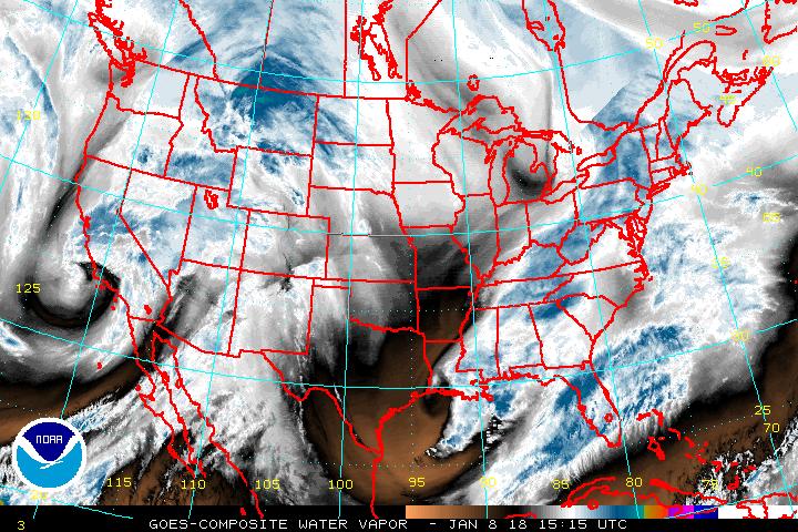
http://www.ssd.noaa.gov/goes/comp/ceus/wv-l.jpg
We are going to begin by looking at the water vapor image above along with the latest surface map from HPC.. Once again you can see the area that will end up being covered by dry air .
Essentially a stationary front is across the US from west to east with ripples or waves of low pressure or if you prefer impulses moving along that front. This front will once again be a focus of severe weather potential..
Now..there is some question as to whether or not the ongoing convective precipitation in the Ohio Valley area will have an effect on that regions severe weather.
http://weather.unisys.com/satellite/sat_ir_us.gif
Satellite shows there is clearing behind this batch of moisture.. so this moisture may help to make the atmosphere a bit more stable and hinder severe potential.
So lets look into the heart of matters with the severe parameters..
Temperatures 70s to 90s
http://www.twisterdata.com/data/models/nam/221/maps/2012/05/02/00/NAM_221_2012050200_F24_TMPF_2_M_ABOVE_GROUND.png
Dew points 60s and 70s
http://www.twisterdata.com/data/models/nam/221/maps/2012/05/02/00/NAM_221_2012050200_F24_DPTF_2_M_ABOVE_GROUND.png
CAPE Values 500-4500 depending on where you are located
http://www.twisterdata.com/data/models/nam/221/maps/2012/05/02/00/NAM_221_2012050200_F24_CAPE_SURFACE.png
Lift index to as low as negative 11 to 12
http://www.twisterdata.com/data/models/nam/221/maps/2012/05/02/00/NAM_221_2012050200_F24_PLI_30_0_MB_ABOVE_GROUND.png
Based on EHI we would place the greatest threat for tornadoes over the Iowa region and perhaps Eastern Nebraska ..
http://www.twisterdata.com/data/models/nam/221/maps/2012/05/02/00/NAM_221_2012050200_F24_EHI_1000_M.png
In the overnight hours the EHI actually increases....
The highest Helicity is actually over E PA
http://www.twisterdata.com/data/models/nam/221/maps/2012/05/02/00/NAM_221_2012050200_F24_HLCY_1000_M_ABOVE_GROUND_0_M_ABOVE_GROUND.png
However we are not anticipating any severe weather making it into eastern PA. So over all the EHI suggests some tornado's are possible but the Helicity negates this factor somewhat. Suggesting super cells could occur with the potential for tornadoes mainly in the area mentioned above..
SHEAR is 35-60 knots across the region depending where you are..
http://www.twisterdata.com/data/models/nam/221/maps/2012/05/02/00/NAM_221_2012050200_F24_SHRM_500_MB.png
The stationary front shown in the surface analysis map will continue to lift northwards as a warm front . This is due to ridging pressing from the south towards the north...
With any storms that do form we will be looking at the potential for very heavy rains. We would break down the percentages like this..
Tornadoes in the area that we mentioned 5% risk with all other areas outside that region at less then 2 %
Winds in excess of 60 MPH 15%
Large Hail 15%
No comments:
Post a Comment