

Generally we like to get this out before SPC gets their outlook out but unfortunately it did not work that way tonight. We originally were not going to do an outlook for today ..not because there was not going to be severe weather but just because of the time factor of not getting it out before them..
We busted on yesterdays outlook in TX..The CAP did break and severe reports did occur there..However..kind of a tit for tat type thing as the slight risk issued by SPC busted in E PA..
We have never claimed to be perfect and you can not get it all ..all the time..
So with that said we took a look at the parameters tonight and we were quite impressed with the area that we have labeled in red..
EHI across this area goes from a 1 to about a 3-4
http://www.twisterdata.com/data/models/nam/221/maps/2012/05/05/00/NAM_221_2012050500_F24_EHI_1000_M.png
HELICITY is also impressive in the same area with 300 +
http://www.twisterdata.com/data/models/nam/221/maps/2012/05/05/00/NAM_221_2012050500_F24_HLCY_1000_M_ABOVE_GROUND_0_M_ABOVE_GROUND.png
SHEAR 40-60 knots
http://www.twisterdata.com/data/models/nam/221/maps/2012/05/05/00/NAM_221_2012050500_F24_SHRM_500_MB.png
LIFT index to about -14 (starting at 0) depending where you are located...
http://www.twisterdata.com/data/models/nam/221/maps/2012/05/05/00/NAM_221_2012050500_F24_PLI_30_0_MB_ABOVE_GROUND.png
CAPE from 500-5000
http://www.twisterdata.com/data/models/nam/221/maps/2012/05/05/00/NAM_221_2012050500_F24_CAPE_SURFACE.png
Temperatures are 70-100's
http://www.twisterdata.com/data/models/nam/221/maps/2012/05/05/00/NAM_221_2012050500_F24_TMPF_2_M_ABOVE_GROUND.png
DEW POINTS in the 60s-70s
http://www.twisterdata.com/data/models/nam/221/maps/2012/05/05/00/NAM_221_2012050500_F24_DPTF_2_M_ABOVE_GROUND.png
So these parameters above with the EHI and HELICITY and CAPE point to a strong case for tornadoes located in the region in red.
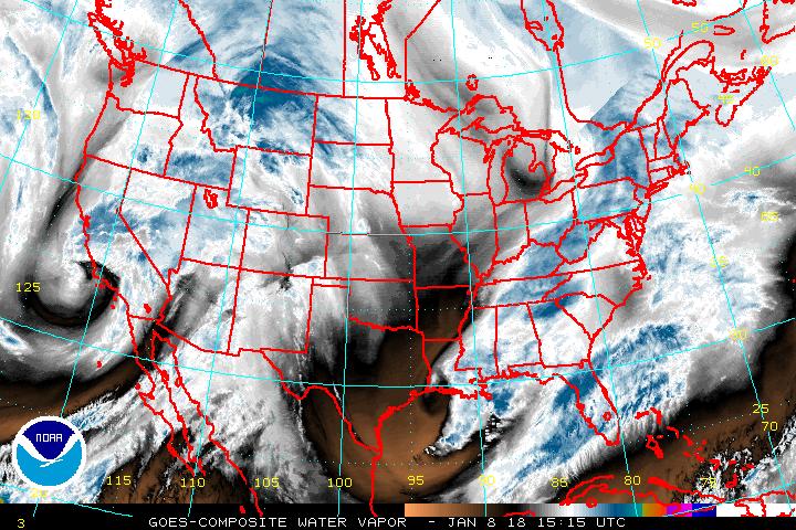
Further to the south into TX.. We have a dry line that will be the focus of some severe weather potential in the form of Hail with lapse rates being around 8.0 . We have to say we were debating about whether or not to include this area with the Water Vapor showing mainly dry air into that region..
http://www.ssd.noaa.gov/goes/comp/ceus/wv-l.jpg
Majority of your guidance such as the NAM/GFS show that this area should be mainly precipitation free which leans more towards what we are seeing with the water vapor image ..they suggest anything that develops would develop south of the FALLS region and that would not be until 7 PM till 1 AM time frame and it kills it off pretty quickly on both those models.
At the surface ... there is ridging across the central part of the USA but a trough and a strong impulse will be moving across the Rocky mountain region towards the Canadian border with a quasi stationary front across the region as well. Also in addition to this will be a cold front that will be moving across the most active zone and this will provide added fuel to what is already a pretty potent parameter atmosphere.
We suggest if you are in that area that you stay tuned to the NWS or your favorite weather source for the latest information.
If a tornado warning should occur ..Make sure you have a plan in place and seek your place of shelter...
If you are outside that area then the risk for severe weather in those zones will be Hail and or Wind unless other wise specified above..
No comments:
Post a Comment